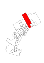
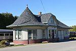
Claremont is an unincorporated community in Southern Ontario in the north part of Pickering, Ontario, Canada. Historically, Claremont was part of Pickering Township, Ontario County, Ontario until 1974 when Ontario County was amalgamated into the Regional Municipality of Durham, which had just been established.
Claremont is one of many rural villages with suburban type housing mixed with older historic buildings in the Greater Toronto Area. Brock Road, the main north-south regional road in the area, was realigned to bypass the village to the east in 1970. Claremont is just below the Oak Ridges Moraine, in the Greenbelt. Typical of the moraine countryside, around 50 to 70% of the land area around Claremont is forested. The remaining land around the village is wooded farmland and streams.
Until the establishment of regional government in 1974, the municipal offices of the former Township of Pickering were located in Claremont.
Access to and traffic through Claremont increased greatly with the completion of the eastern extension of the Highway 407, which has terminated at the Brock Road exit since 2001.
The Havelock Subdivision of the Canadian Pacific Railway runs through Claremont. This line is used for freight traffic, but there have been proposals for the return of passenger service as part of a GO Transit expansion to Peterborough.
Claremont is located 20 km northwest of Oshawa and about 55 km northeast of Downtown Toronto.
Claremont has a elementary school from junior kindergarten to grade 8 and also has a cafe and a convenience store.


