Brookfield (CDP), Massachusetts
Census-designated places in MassachusettsCensus-designated places in Worcester County, MassachusettsUse mdy dates from July 2023Worcester County, Massachusetts geography stubs

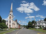
Brookfield is a census-designated place (CDP) comprising the main village in the town of Brookfield, Worcester County, Massachusetts, United States. Massachusetts Route 9 passes through the center of the village, leading east 6 miles (10 km) to Spencer and west 9 miles (14 km) to Ware. Massachusetts Route 148 crosses Route 9 in the village center, leading north 4 miles (6 km) to North Brookfield and south 7 miles (11 km) to Fiskdale. Brookfield was first listed as a CDP after the 2010 census.
Excerpt from the Wikipedia article Brookfield (CDP), Massachusetts (License: CC BY-SA 3.0, Authors, Images).Brookfield (CDP), Massachusetts
River Street,
Geographical coordinates (GPS) Address Nearby Places Show on map
Geographical coordinates (GPS)
| Latitude | Longitude |
|---|---|
| N 42.216111111111 ° | E -72.102777777778 ° |
Address
River Street
River Street
01585
Massachusetts, United States
Open on Google Maps


