Middleton, Norfolk

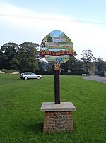
Middleton is a village and civil parish in the English county of Norfolk. It covers an area of 5.02 sq mi (13.0 km2) and had a population of 1,516 in 621 households at the 2001 census, reducing to 1,450 at the 2011 Census.The village's name means 'Middle farm/settlement'. Middleton is the second village on the A47 road to Norwich, after North Runcton, and lies approximately 3 miles (5 km) east of King's Lynn. The A47, the main road of Norfolk, effectively divides the village in two, and has long been a site of road traffic accidents. Fair Green and Blackborough End are also areas of Middleton. Fair Green is on the northern part of the village, whilst Blackborough End is in the southern half of the village. Middleton has a primary school, Middleton V.C. Primary School, a village hall, a post office and a car repair garage called Total Motors. The village church is called Saint Mary's, and the current Rector is the Revd Jim Ryan. The church is situated beside the A47, opposite the Middletons Steakhouse & Grill. The village had a petrol filling station, but this closed during the 1990s. The village also has a golf club.
Excerpt from the Wikipedia article Middleton, Norfolk (License: CC BY-SA 3.0, Authors, Images).Middleton, Norfolk
Lynn Road, King's Lynn and West Norfolk Middleton
Geographical coordinates (GPS) Address Nearby Places Show on map
Geographical coordinates (GPS)
| Latitude | Longitude |
|---|---|
| N 52.717 ° | E 0.467 ° |
Address
Lynn Road
Lynn Road
PE32 1NG King's Lynn and West Norfolk, Middleton
England, United Kingdom
Open on Google Maps


