place

Webster Lake (New Hampshire)

Lakes of Merrimack County, New HampshireNew Hampshire geography stubs
Webster Lake, Franklin NH

Webster Lake is a 606-acre (2.45 km2) water body in West Franklin, a village of Franklin in Merrimack County in the central portion of the U.S. state of New Hampshire. Water from Webster Lake flows to the Pemigewasset River shortly above its confluence with the Winnipesaukee River to form the Merrimack. Webster Lake has two public beaches operated by the city of Franklin, one on either side of the lake. Webster Lake is surrounded by forests, and roads follow most of the lakeshore, allowing frequent views. There is boating access adjacent to Lagace Beach on New Hampshire Route 11. The lake is classified as a warmwater fishery, with observed species including rainbow trout, brown trout, smallmouth and largemouth bass, chain pickerel, horned pout, and white perch.

Excerpt from the Wikipedia article Webster Lake (New Hampshire) (License: CC BY-SA 3.0, Authors, Images).

Webster Lake (New Hampshire)
Franklin

Geographical coordinates (GPS) Address Nearby Places
placeShow on map

Wikipedia: Webster Lake (New Hampshire)Continue reading on Wikipedia

Geographical coordinates (GPS)

Latitude Longitude
N 43.469444444444 ° E -71.686388888889 °
placeShow on map

Address

Webster Lake


03235 Franklin
New Hampshire, United States
mapOpen on Google Maps

Webster Lake, Franklin NH
Share experience

Nearby Places

Winnipesaukee River
Winnipesaukee River

The Winnipesaukee River is a 10.5-mile-long (16.9 km) river that connects Lake Winnipesaukee with the Pemigewasset and Merrimack rivers in Franklin, New Hampshire. The river is in the Lakes Region of central New Hampshire. The river's drainage area is approximately 488 square miles (1,264 km2). The river has two distinct sections. The upstream section consists of a series of river courses connecting a chain of lakes, beginning with Lake Winnipesaukee. From the dam at the outlet of Lake Winnipesaukee in the Lakeport section of Laconia, the river almost immediately enters Opechee Bay. 1 mile (1.6 km) down the lake, the river exits over a dam and drops through the center of Laconia, its banks lined by industrial buildings from the 19th century that were constructed to take advantage of the river's power. The 1-mile (1.6 km) section through Laconia ends at Lake Winnisquam, the fourth-largest lake in New Hampshire. A 5-mile (8 km) stretch across Winnisquam leads to the dam at the lake's outlet and a short descent to Silver Lake. The river's lower section begins at the natural outlet of Silver Lake, on the boundary between Belmont and Tilton, New Hampshire. The river passes through the center of the twin towns of Tilton and Northfield, then descends through a narrow valley to Franklin where additional small dams use the river's power. From Tilton to Franklin, the river has a drop of up to 90 feet per mile (17 m/km), with challenging rapids for sport boaters who put in at Cross Mill Bridge and take out at the U.S. Route 3 Sanborn Bridge in downtown Franklin. A USGS water gage is in Tilton.The Winnipesaukee River joins the Pemigewasset River just downstream from the center of Franklin, forming the Merrimack River.

Concord Historic District

The Concord Historic District encompasses the least altered portion of the historic heart of Concord, New Hampshire. The 25-acre (10 ha) district, located just north of the modern commercial and civic heart of the city, includes the city's oldest surviving house, the site of its first religious meetinghouse, and the Pierce Manse, a historic house museum that was home to President Franklin Pierce during his rise to national prominence. The district was listed on the National Register of Historic Places in 1975.The original heart of Concord was platted out in 1726, on a terrace above the floodplains on the western banks of the Merrimack River. The lots, about 1.5 acres (0.61 ha) in size, were arrayed in the vicinity of Horseshoe Pond, and it is the earliest of these that make up the district. The area is characterized by a uniformity of setting, despite a diversity in architectural style, in part because most of the buildings are similarly-sized dwellings set on equal-sized lots. Larger buildings, including a church, school, and professional offices, stand on larger lots.The oldest surviving house, that of Reverend Timothy Walker, was built in 1735. It was also the first house in the area to be garrisoned (fortified and surrounded by a palisade) against Native attacks. The district was also home to Concord's first meeting house (no longer extant). The residential structures in the district represent the variety of architectural styles popular during the 19th century, including the fine Greek Revival Pierce Manse, a Victorian Gothic cottage at 278 North Main Street, and the late Gothic brick house at 266 North Main Street. There are only a few buildings in the district built after the 1920s, among them the Lutheran church.

East Andover Village Center Historic District

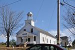
The East Andover Village Center Historic District encompasses the historic village center of East Andover, New Hampshire, United States. The 2.2-acre (0.89 ha) district includes a cemetery and three buildings: the Andover Congregational Church, the Highland Lake Grange Hall, and the East Andover Schoolhouse. It is located at the corner of New Hampshire Route 11 and Chase Hill Road. The district is unified by the appearance of the three buildings (all are sheathed in clapboards and painted white), and their styling, which is predominantly vernacular 19th century. The Andover Congregational Church is the oldest of the three buildings, built in 1796 to provide space for civic and religious functions in the town. It is a two-story wood-frame building, with a pair of entrances on the main facade, which provide access to a vestibule area, from which access to the main hall is gained, with stairs leading up to galleries on either side. The building was used by the town for meetings and by several religious organizations for services, but had by 1822 fallen into some disrepair. It was extensively rebuilt in 1840, including turning the building so that its main facade faced south. This work including the addition of the tower and the Greek Revival styling the building now shows. It has received only minor modifications since then.The Old North Church Cemetery was deeded to the town in 1805, although it seems to have been used before then, since at least two burials predate this transfer. Burial plots are laid out in north–south rows in the half-acre cemetery, which was filled up by the late 19th century. The cemetery stretches out along Route 11, behind (north of) the church. The Highland Lake Grange Hall was built in 1850 by the Mountain Club, an East Andover literary club that sought a meeting place for itself, and wanted to promote secondary education in the town. The building was inaugurated that year as the Highland Lake Institute, an academy that lasted just five years. It then saw a succession of academic and civic uses, and was enlarged in 1893 and renamed Union Hall. In 1938 the Union Hall Associates sold the building to the local grange chapter, which had been meeting on the premises since 1894. Little modification has been made to the building since 1893.The East Andover Schoolhouse was built in 1903 to replace the old District 10 schoolhouse, which had been located just south of the grange hall. Located just east of the grange hall, the building served as a public school until 1962; its most significant alteration in this period was the addition of a wood and coal shed to the rear. The building was sold to the church, which has since used it for Sunday School and as a nursery.The district was listed on the National Register of Historic Places in 1989.