place

Goodland-Grant Township Public Library

Buildings and structures in Newton County, IndianaColonial Revival architecture in IndianaLibraries on the National Register of Historic Places in IndianaLibrary buildings completed in 1931National Register of Historic Places in Newton County, Indiana
Northern Indiana Registered Historic Place stubsUse mdy dates from March 2025
Goodland Grant Township Public Library

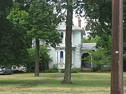
Goodland-Grant Township Public Library, also known as the Mitten Memorial Building, is a historic library building located at Goodland, Newton County, Indiana. It was built in 1931, and is a one-story, rectangular, Colonial Revival style steel frame building on a raised basement. It has hollow tile walls, is sheathed in limestone, and has a slate gable roof.: 5  It was listed on the National Register of Historic Places in 2004.

Excerpt from the Wikipedia article Goodland-Grant Township Public Library (License: CC BY-SA 3.0, Authors, Images).

Goodland-Grant Township Public Library
South Newton Street,

Geographical coordinates (GPS) Address Nearby Places
placeShow on map

Wikipedia: Goodland-Grant Township Public LibraryContinue reading on Wikipedia

Geographical coordinates (GPS)

Latitude Longitude
N 40.765 ° E -87.293055555556 °
placeShow on map

Address

Grant Township Trustee

South Newton Street
47948
Indiana, United States
mapOpen on Google Maps

Goodland Grant Township Public Library
Share experience

Nearby Places

Kentland crater
Kentland crater

The Kentland structure, also known as the Kentland crater or the Kentland disturbed area, is an impact structure located near the town of Kentland in Newton County, Indiana, United States.It was discovered about 1880 when two farmers began to quarry crushed rock there. The presence of shatter cones and deformed bedrock led geologists to conclude by the late 1960s that the Kentland structure is a deeply eroded impact structure, rather than volcanic in origin. Deformation at the site is so great that vertical contacts between normally horizontal rock formations of different ages are common. The structure itself is a circular dome, about 7.24 km (4.50 mi) in diameter, deeply eroded and buried in glacial debris. Its age is estimated to be less than 97 million years (Cretaceous or younger). The Shakopee dolomite at the center of the structure is about 450 million years old (Ordovician period) and is uplifted about 2,000 feet higher than the level of the same rock in the surrounding area. The entire disturbed area is about 13 km (8.1 mi) in diameter. The estimated age is in dispute. ‘"97 MYA‘" Late Cretaceous Period of the Mesozoic Era ‘"300 MYA‘= Bzhelian or Late Pennsylvanian Epoch (Carboniferous Period) of the Paleozoic EraThis impact structure was studied in 1978. John Weber and his associates presented fission track dating of apatite from this impact structure. Coesite and shatter cones are found in the uplift near its center. The impact structure is exposed to the surface, resulting in erosion. It is currently being worked as a quarry.