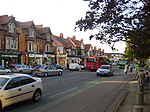
Banbury Road
Infobox road instances in EnglandInfobox road maps tracking categoryKellogg College, OxfordRoads in OxfordshireSt Anne's College, Oxford ... and 4 more
St Hugh's College, OxfordStreets in OxfordUse British English from August 2010Wycliffe Hall, Oxford

Banbury Road is a major arterial road in Oxford, England, running from St Giles' at the south end, north towards Banbury through the leafy suburb of North Oxford and Summertown, with its local shopping centre. Parallel and to the west is the Woodstock Road, which it meets at the junction with St Giles'. To the north, Banbury Road meets the Oxford Ring Road at a roundabout. The road is designated the A4165 (which continues for a short distance as Oxford Road to Kidlington). Prior to the building of the M40 motorway extension in 1990, the road formed part of the A423 from Maidenhead to Coventry.
Excerpt from the Wikipedia article Banbury Road (License: CC BY-SA 3.0, Authors, Images).Banbury Road
Banbury Road, Oxford Cutteslowe
Geographical coordinates (GPS) Address Nearby Places Show on map
Geographical coordinates (GPS)
| Latitude | Longitude |
|---|---|
| N 51.78133 ° | E -1.26652 ° |
Address
Banbury Road 356
OX2 7PP Oxford, Cutteslowe
England, United Kingdom
Open on Google Maps


