Scharwoude, Koggenland
KoggenlandNorth Holland geography stubsPages with non-numeric formatnum argumentsPopulated places in North Holland

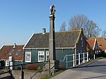
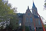
Scharwoude is a village in the Dutch province of North Holland. It is a part of the municipality of Koggenland, and lies about 5 km southwest of Hoorn. The village was first mentioned around 1312 as Scaderwoude. The etymology is unclear. Scharwoude often experienced floods due to its proximity to the former Zuiderzee. It was flooded in 1375. The current shape of the dike and the village date from 1854. The former church dates from 1892. It was decommissioned in 1986, and is now a residential home.
Excerpt from the Wikipedia article Scharwoude, Koggenland (License: CC BY-SA 3.0, Authors, Images).Scharwoude, Koggenland
IJselmeerdijk, Koggenland
Geographical coordinates (GPS) Address Nearby Places Show on map
Geographical coordinates (GPS)
| Latitude | Longitude |
|---|---|
| N 52.616666666667 ° | E 5.0166666666667 ° |
Address
IJselmeerdijk 17
1634 DM Koggenland
North Holland, Netherlands
Open on Google Maps


