Haastrecht

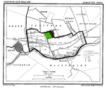
Haastrecht is a town on the Hollandse IJssel river in the Dutch province of South Holland. It is a part of the municipality of Krimpenerwaard, and lies about 5 km east of Gouda. In 2001, the town of Haastrecht had 3302 inhabitants. The built-up area of the town was 0.58 km², and contained 1325 residences. The statistical area "Haastrecht", which also can include the peripheral parts of the village, as well as the surrounding countryside, has a population of around 2330.Haastrecht received city rights in 1396. It remained a separate municipality until 1985, when it became part of Vlist. The name is quite funny, because it sounds like "hast Recht", which means "you're right" in German.
Excerpt from the Wikipedia article Haastrecht (License: CC BY-SA 3.0, Authors, Images).Haastrecht
Provincialeweg West, Krimpenerwaard
Geographical coordinates (GPS) Address Nearby Places Show on map
Geographical coordinates (GPS)
| Latitude | Longitude |
|---|---|
| N 52 ° | E 4.7666666666667 ° |
Address
v.v. Haastrecht
Provincialeweg West
2851 TJ Krimpenerwaard
South Holland, Netherlands
Open on Google Maps


