City of Boroondara
1994 establishments in AustraliaLocal government areas in MelbournePopulated places established in 1994Use Australian English from August 2019

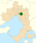
The City of Boroondara () is a local government area in Victoria, Australia. It is located in the eastern suburbs of Melbourne. It was formed in June 1994 from the amalgamation of the Cities of Kew, Camberwell and Hawthorn.It has an area of 60 km2 (23.2 sq mi). In June 2018 the City had a population of 181,289. Boroondara was rated ninth of 590 Australian local government areas in the BankWest Quality of Life Index 2008, and first in a 2013 Victoria-wide community satisfaction survey.
Excerpt from the Wikipedia article City of Boroondara (License: CC BY-SA 3.0, Authors, Images).City of Boroondara
Mont Albert Road, Melbourne Canterbury
Geographical coordinates (GPS) Address Nearby Places Show on map
Geographical coordinates (GPS)
| Latitude | Longitude |
|---|---|
| N -37.816666666667 ° | E 145.06666666667 ° |
Address
Camberwell Grammar School
Mont Albert Road 43-65
3103 Melbourne, Canterbury
Victoria, Australia
Open on Google Maps


