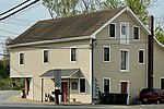
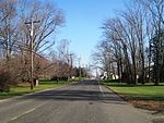
Coxs Corner, Monmouth County, New Jersey
Monmouth County, New Jersey geography stubsUnincorporated communities in Monmouth County, New JerseyUnincorporated communities in New JerseyUpper Freehold Township, New JerseyUse American English from July 2023 ... and 1 more
Use mdy dates from July 2023

Coxs Corner, also known as Cox's Corner or Wrightsville, is an unincorporated community located within Upper Freehold Township, in Monmouth County, in the U.S. state of New Jersey. Named for congressman and brigadier general James Cox (1753–1810), who had lived here at the family home of "Box Grove", it is at the juncture of County Route 524 and County Route 43. The Upper Freehold Historic Farmland Byway passes through the area.
Excerpt from the Wikipedia article Coxs Corner, Monmouth County, New Jersey (License: CC BY-SA 3.0, Authors, Images).Coxs Corner, Monmouth County, New Jersey
Stone Tavern Road,
Geographical coordinates (GPS) Address Nearby Places Show on map
Geographical coordinates (GPS)
| Latitude | Longitude |
|---|---|
| N 40.181666666667 ° | E -74.511388888889 ° |
Address
Stone Tavern Road 689
08501
New Jersey, United States
Open on Google Maps


