Newark and Sherwood
Newark and SherwoodNon-metropolitan districts of NottinghamshirePages containing links to subscription-only contentUse British English from June 2020Vague or ambiguous time from December 2023

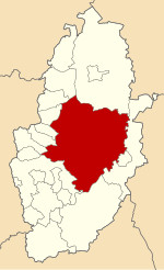
Newark and Sherwood is a local government district in Nottinghamshire, England. It is the largest district by area in the county. The council is based in Newark-on-Trent, the area's largest town. The district also includes the towns of Southwell and Ollerton along with a large rural area containing many villages. Much of the district lies within the ancient Sherwood Forest and there are also extensive forestry plantations in the area. The neighbouring districts are Rushcliffe, Gedling, Ashfield, Mansfield, Bassetlaw, West Lindsey, North Kesteven and South Kesteven.
Excerpt from the Wikipedia article Newark and Sherwood (License: CC BY-SA 3.0, Authors, Images).Newark and Sherwood
A617, Newark and Sherwood
Geographical coordinates (GPS) Address Nearby Places Show on map
Geographical coordinates (GPS)
| Latitude | Longitude |
|---|---|
| N 53.1 ° | E -0.95 ° |
Address
A617
NG25 0PH Newark and Sherwood
England, United Kingdom
Open on Google Maps


