place

St Saviour's Church, York

Church of England church buildings in YorkFormer Church of England church buildingsGrade II* listed churches in YorkSt SaviourgateUse British English from December 2017
Church of St Saviour, York

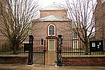
St Saviour's Church, on St Saviourgate in York, also known as St Saviour in the Marsh (ecclesia sancti salvatoris in Marisco) is a Grade II* listed former parish church in the Church of England in York.

Excerpt from the Wikipedia article St Saviour's Church, York (License: CC BY-SA 3.0, Authors, Images).

St Saviour's Church, York
St Saviourgate, York Bishophill

Geographical coordinates (GPS) Address Phone number Website External links Nearby Places
placeShow on map

Wikipedia: St Saviour's Church, YorkContinue reading on Wikipedia

Geographical coordinates (GPS)

Latitude Longitude
N 53.959558333333 ° E -1.0780833333333 °
placeShow on map

Address

Jorvik DIG

St Saviourgate
YO1 8NN York, Bishophill
England, United Kingdom
mapOpen on Google Maps

Phone number
York Archaeological Trust

call+441904615505

Website
digyork.com

linkVisit website

linkWikiData (Q20128209)
linkOpenStreetMap (59108415)

Church of St Saviour, York
Share experience

Nearby Places

York
York

York is a cathedral city in North Yorkshire, England, with Roman origins, sited at the confluence of the rivers Ouse and Foss. It is the historic county town of Yorkshire. The city has many historic buildings and other structures, such as a minster, castle, and city walls. It is the largest settlement and the administrative centre of the wider City of York district. The city was founded under the name of Eboracum in 71 AD. It then became the capital of the Roman province of Britannia Inferior, and later of the kingdoms of Deira, Northumbria, and Scandinavian York. In the Middle Ages, it became the northern England ecclesiastical province's centre, and grew as a wool-trading centre. In the 19th century, it became a major railway network hub and confectionery manufacturing centre. During the Second World War, part of the Baedeker Blitz bombed the city; it was less affected by the war than other northern cities, with several historic buildings being gutted and restored up to the 1960s.The city is one of 15 in England to have a lord mayor, and one of three to have The Right Honourable title affixed, the others being London's and Bristol's. Historic governance of the city was as a county corporate, not included in the county's riding system. The city has since been covered by a municipal borough, county borough, and since 1996 a non-metropolitan district (the City of York), which also includes surrounding villages and rural areas, and the town of Haxby. The current district's local council is responsible for providing all local services and facilities throughout this area. The city had a population of 153,717 in the 2011 census; the wider district had a population of 198,100. According to 2021 census data, the wider district has a population of 202,800, a 2.4% increase compared to the 2011 census.

Central Methodist Church, York

The Central Methodist Church is a Grade II* listed building in the city centre of York in England. The church lies on St Saviourgate. It was constructed in 1840, as the Centenary Chapel, marking the 100th anniversary of the founding of the first Methodist societies.The building was designed by James Simpson in a classical style, with an Ionic portico. It consists of a basement and two stories above. To its rear, he built vestries, classrooms, band rooms, and a house for a caretaker. In 1861, the buildings to the rear were extended, to provide more classroom space. They burned down in 1863, and though they were rebuilt, they again burned down, and were again replaced in 1872. The chapel was extended in 1881 and 1885, the schoolrooms were extended in 1895, and two new vestries were added in 1909.In 1887, the chapel became the head of a circuit. In 1908 and 1926, it hosted meetings of the Wesleyan Methodist Conference. In 1982, its congregation merged with that of the Wesley Chapel, Priory Street, and it was then renamed as the "Central Methodist Church". The chapel can seat 1,500 worshippers in a horseshoe formation, some on oval gallery above. On the ground floor, there are original numbered box pews. The three-manual organ with 2,500 pipes was installed by John Brown in 1841 and rebuilt in 1931. Notable monuments include a sarcophagus dedicated to Joseph Agar, and a tabernacle dedicated to the Reverend David Hill, a local missionary to China.The church hosts regular services, although as of 2016 its congregation averaged only 45. It also holds Carecent breakfasts for homeless and disadvantaged people. The building provides space for some charities and voluntary groups in first floor offices. In 2016, its minister announced plans to add a new reception space, improve access for disabled people, and start offering the space as a community centre during the week.In October 2021, the church was one of 142 sites across England to receive part of a £35-million injection into the government's Culture Recovery Fund.

Lady Hewley's Almshouses

Lady Hewley's Almshouses are a historic building in the city centre of York, in England. Sarah Hewley founded almshouses on Tanner Row in 1700, run by the Lady Hewley Trust. These were demolished to allow the construction of York's original railway station, and a replacement building on St Saviourgate was completed in 1841. The construction cost £1,711. The buildings are still in use as almshouses, and are still run by the same trust.The building was designed by James Pigott Pritchett, in a Tudor Revival style. The building formerly had nine apartments and a chapel, but in 1975, the chapel was converted into an additional apartment. The front of the almshouses is of stone, and the rear of brick. The building is two storeys high, with a cellar. Its main part has nine windows on each floor, and there are wings at either end. The front has three entrance doors, while there are two doors in the right-hand facade, which overlooks Stonebow. Inside, movable panels partition the entrance halls. The original kitchen ranges survive, as do the first floor fireplaces, although these are now blocked. The warden's house has two storeys and a three bay front, and is built of stone. In the 20th century, a single-storey extension was added to the right of the building. There is a tablet in the end wall, moved from the original building, which records its foundation. The buildings were Grade II listed in 1954; the gate piers and railings also form part of the listing.

York Carmelite Friary

York Carmelite Friary was a friary in York, North Yorkshire, England, that was established in about 1250, moved to its permanent site in 1295 and was surrendered in 1538. The original site was on Bootham in York until 1295 when William de Vescy gave the Carmelite friars a tenement in Stonebow Lane which extended as far south as the River Foss and from east to west between the streets of Fossgate and 'Mersk'. Within five years the friary church was under construction followed by the consecration of a cemetery in 1304 and the church in 1328. A royal licence was granted in 1314 that allowed the friars to build a quay on the Fishpond of the Foss and keep a boat that enabled the transporting of building materials. This licence and the gift of additional lands was followed by a number of extensions that took place throughout the 14th century culminating in the rebuilding of the church in 1392 as the friary eventually extended as far east as Hungate. The location of friary land within the parishes of St Crux and St Saviour meant that from 1301 an annual payment to St Saviour's was established following complaints from St Mary's convent to whom the church was appropriated. In 1320 Archbishop Melton stated that annual compensation was to be paid to the rector of St Crux and in 1350 the friary was restricted in the use of its chapel. The chapel, which was located above the gatehouse at the northern end of the friary, contained a life-size statue of the Virgin Mary which attracted many pilgrims, but the friars were made to remove the statue.The last Prior of the Carmelite friary, Simon Clerkson, was a supporter of the Henrician regime and, after the dissolution, was granted the vicarage of Rotherham. The friary was surrendered to Sir George Lawson in 1538 after which the site was leased to a Ralph Beckwith in 1540 and his family held the land until 1614. A few monuments and architectural fragments from the friary are in the collection of the Yorkshire Museum in York. The location of the friary can be found on several historical maps up to 1852 including Speed's map of 1610 and Baines of 1822, however the modern street pattern has significantly changed. The friary has been completely built over, however it is thought that the limestone masonry incorporated into buildings on the site may have been from the walls of the friary. In the 1990s the public house (since renamed The Terrace) on the corner of Fossgate and Stonebow was called the Northern Wall in reference to its location on the site of the former friary.In 1995, the Carmelites returned to work in York when they were invited by the Diocese of Middlesbrough to be chaplains at More House to the University of York.