Electoral district of Box Hill
1945 establishments in AustraliaCity of WhitehorseElectoral districts and divisions of Greater MelbourneElectoral districts of Victoria (state)Pages with disabled graphs ... and 1 more
Victoria (state) government stubs

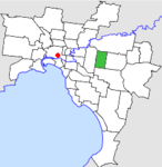
The electoral district of Box Hill is an electoral district of the Victorian Legislative Assembly, covering an area of 29 square kilometres (11 sq mi) in eastern Melbourne. It contains the suburbs of Box Hill, Box Hill North, Box Hill South, Mont Albert, Mont Albert North, most of Blackburn, Blackburn North, and Blackburn South, and parts of Balwyn North, Burwood, Burwood East, and Surrey Hills. It lies within the Eastern Metropolitan Region in the upper house, the Legislative Council.
Excerpt from the Wikipedia article Electoral district of Box Hill (License: CC BY-SA 3.0, Authors, Images).Electoral district of Box Hill
Wattle Street, Melbourne Box Hill North
Geographical coordinates (GPS) Address Nearby Places Show on map
Geographical coordinates (GPS)
| Latitude | Longitude |
|---|---|
| N -37.81 ° | E 145.12 ° |
Address
Wattle Street
Wattle Street
3129 Melbourne, Box Hill North
Victoria, Australia
Open on Google Maps


