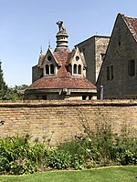
Tyringham
Buckinghamshire geography stubsMilton KeynesTyringhamVillages in Buckinghamshire

Tyringham (/ˈtiːrɪŋəm/) is a village in the unitary authority area of the City of Milton Keynes, Buckinghamshire, England. It is located about a mile and a half north of Newport Pagnell. The village name is an Old English language word, and means 'Tir's home'. In the Domesday Book of 1086 the village was recorded as Telingham. There is a theory that the name Tyringham refers to a settlement of Thuringii Germans coming with the Anglo-Saxons in the Dark Ages.
Excerpt from the Wikipedia article Tyringham (License: CC BY-SA 3.0, Authors, Images).Tyringham
Fences Lane,
Geographical coordinates (GPS) Address Nearby Places Show on map
Geographical coordinates (GPS)
| Latitude | Longitude |
|---|---|
| N 52.114 ° | E -0.745 ° |
Address
Fences Lane
Fences Lane
MK16 9EN , Tyringham and Filgrave
England, United Kingdom
Open on Google Maps


