Ma Shi Chau
Hong Kong UNESCO Global GeoparkHong Kong geography stubsIslands of Hong KongTai Po DistrictTidal islands ... and 2 more
TombolosUninhabited islands of Hong Kong

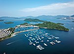
Ma Shi Chau (Chinese: 馬屎洲; Sidney Lau: Ma5Si2Jau1, literally "Horse Dung Island") is an island of Hong Kong, under the administration of Tai Po District. It is located in Tolo Harbour in the northeast New Territories (near Sam Mun Tsai). It is connected with another island, Yim Tin Tsai, by a tombolo traversable at low tide. It was previously known as No Kot Chai and No Kot Choi (Chinese: 螺角洲).
Excerpt from the Wikipedia article Ma Shi Chau (License: CC BY-SA 3.0, Authors, Images).Ma Shi Chau
馬屎洲自然教育徑 Ma Shi Chau Nature Trail, Tai Po District
Geographical coordinates (GPS) Address Nearby Places Show on map
 Continue reading on Wikipedia
 Geographical coordinates (GPS)
| Latitude | Longitude |
|---|---|
| N 22.453872222222 ° | E 114.22925833333 ° |
Address
馬屎洲自然教育徑 Ma Shi Chau Nature Trail
馬屎洲自然教育徑 Ma Shi Chau Nature Trail
Tai Po District
Hong Kong, China
Open on Google Maps