Yeung Chau, Tai Po District
Hong Kong geography stubsIslands of Hong KongTai Po DistrictUninhabited islands of Hong Kong

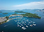
Yeung Chau (Chinese: 洋洲) is an uninhabited island of Hong Kong located in Plover Cove, Tolo Harbour, in the northwestern part of the territory. Administratively, it is part of Tai Po District.
Excerpt from the Wikipedia article Yeung Chau, Tai Po District (License: CC BY-SA 3.0, Authors, Images).Yeung Chau, Tai Po District
Tai Po District
Geographical coordinates (GPS) Address Nearby Places Show on map
 Continue reading on Wikipedia
 Geographical coordinates (GPS)
| Latitude | Longitude |
|---|---|
| N 22.461405 ° | E 114.221371 ° |
Address
牛寮下 Ngau Liu Ha
Tai Po District
Hong Kong, China
Open on Google Maps