Ma Shi Chau Special Area
Asian protected area stubsCommons link is defined as the pagenameCountry parks and special areas of Hong KongHong Kong geography stubsTai Po District

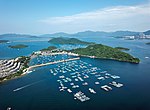
Ma Shi Chau Special Area (Chinese: 馬屎洲特別地區) is a Special Area of Hong Kong. It is located in Tai Po District and in Tolo Harbour, in the northeast of the New Territories. The Special Area comprises four islands in Tolo Harbour, namely Ma Shi Chau, Centre Island, Yeung Chau and an unnamed island located about 100 metres (330 ft) northeast of the shore of Yim Tin Tsai near Sam Mun Tsai New Village.It was designated in 1999 and covers 61 hectares.This area is considered a geological wonder, there are rocks over 280 million years old from the Permian period.
Excerpt from the Wikipedia article Ma Shi Chau Special Area (License: CC BY-SA 3.0, Authors, Images).Ma Shi Chau Special Area
馬屎洲自然教育徑 Ma Shi Chau Nature Trail, Tai Po District
Geographical coordinates (GPS) Address Nearby Places Show on map
 Continue reading on Wikipedia
 Geographical coordinates (GPS)
| Latitude | Longitude |
|---|---|
| N 22.4533 ° | E 114.2287 ° |
Address
鹽田仔及馬屎洲具特殊科學價值地點 Yim Tin Tsai & Ma Shi Chau SSSI
馬屎洲自然教育徑 Ma Shi Chau Nature Trail
Tai Po District
Hong Kong, China
Open on Google Maps