place

Holborn Viaduct

Bridges in the City of LondonBuildings and structures in HolbornGrade II listed bridges in LondonGrade II listed buildings in the City of LondonHarv and Sfn no-target errors
Streets in the City of LondonUse British English from November 2014Viaducts in England
Holborn Viaduct, London 14440858913

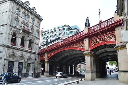
Holborn Viaduct is a road bridge in London and the name of the street which crosses it (which forms part of the A40 route). It links Holborn, via Holborn Circus, with Newgate Street, in the City of London financial district, passing over Farringdon Street and the subterranean River Fleet. The viaduct spans the steep-sided Holborn Hill and the River Fleet valley at a length of 1,400 feet (430 m) and 80 feet (24 m) wide. City surveyor William Haywood was the architect and the engineer was Rowland Mason Ordish.

Excerpt from the Wikipedia article Holborn Viaduct (License: CC BY-SA 3.0, Authors, Images).

Holborn Viaduct
Farringdon Street, City of London

Geographical coordinates (GPS) Address External links Nearby Places
placeShow on map

Wikipedia: Holborn ViaductContinue reading on Wikipedia

Geographical coordinates (GPS)

Latitude Longitude
N 51.517197222222 ° E -0.10506944444444 °
placeShow on map

Address

Holborn Viaduct

Farringdon Street
EC4A 4AN City of London
England, United Kingdom
mapOpen on Google Maps

linkWikiData (Q4581944)
linkOpenStreetMap (378321785)

Holborn Viaduct, London 14440858913
Share experience

Nearby Places

Farringdon Market
Farringdon Market

Farringdon Market was a market erected in 1829 to replace the Fleet Market, which had been cleared for the widening of Farringdon Street and Farringdon Road. The market was between Farringdon Street east and Shoe Lane west, north of Stonecutter Street, in the City of London ward of Farringdon Without.The market covered 1.5 acres (0.01 km2) and cost about £250,000. On 20 November 1829, the market opened and was described in a contemporary account: "It forms a handsome and elevated quadrangle, of 232 feet by 150 feet. The purchase of the ground, and the buildings which stood thereon, is estimated in round numbers at £200,000; the building of the market, including paviours' accounts, &c., is stated at £80,000. The avenue under which are the shops of the dealers, and which extends round three sides of the building, is 25 feet high, to what are technically termed the tie-beams, with ventilators ranged at equal distances. … In the centre of the roof of the principal avenue a turret and clock have been placed. … The chief entrance to the market is by two gates, for wagons, &c., in Stonecutter Street, which has been made double its former width, and two smaller ones for footpassengers; besides these, on each side of the quadrangle, massive oak doors are to be thrown open, from morning till the close of public business."The market was not successful, and at a meeting of the Court of Common Council, on 29 June 1874, the takings were described as not averaging more than £225 per annum over the preceding five years. The market required improvement and its approach was along the steep sides of the Holborn valley — the former location of the River Fleet. The market also faced stiff competition from Borough Market and Covent Garden. The Corporation decided that the market would be relocated to a new fruit and vegetable hall at nearby Smithfield between 1879 and 1883.Henry Mayhew visited the market one November morning. The poor, he says, were there, in every style of rags, laying in the necessary stock for their trade [of selling watercress in the streets]. "As the morning twilight drew on, the paved court was crowded with customers. The sheds and shops at the end of the market grew every moment more distinct, and a railway van, laden with carrots, came rumbling into the yard. The pigeons, too, began to fly into the sheds, or walk about the paving-stones, and the gas-man came round with his ladder to turn out the lamps. Then every one was pushing about, the children crying as their naked feet were trodden upon, and the women hurrying off with their baskets or shawls filled with cresses, and the bunch of rushes in their hands. In one corner of the market, busily tying up their bunches, were three or four girls, seated on the stones, with their legs curled up under them, and the ground near them was green with the leaves they had thrown away. A saleswoman, seeing me looking at the group, said, 'Ah, you should come here of a summer's morning, and then you'd see 'em, sitting tying up, young and old, upwards of a hundred poor things, as thick as crows in a ploughed field.'"
Snow Hill tunnel (London)

Snow Hill tunnel is a railway tunnel on the northern edge of the City of London which carries the up and down Snow Hill lines between City Thameslink and Farringdon stations. The tunnel runs beneath the Smithfield meat market and was constructed, using the cut-and-cover method, immediately prior to the building of the market. The tunnel opened on 1 January 1866. Snow Hill tunnel was constructed by the London, Chatham and Dover Railway (LC&DR) to connect its line from Herne Hill to the recently opened Metropolitan Railway's Widened Lines, south of Farringdon station. To the north-west, the Widened Lines in turn connected to the tracks of the Great Northern Railway at King's Cross, and the Midland Railway at St Pancras, via tunnels running beneath the two main line termini. Snow Hill tunnel thus provided the crucial link in the only north–south railway route through central London, enabling a number of main line railway companies to run cross-London passenger and goods services. In 1871, an additional, eastwards tunnel was opened, which had connection to the Metropolitan Railway's tracks, enabling trains from the south to also serve Aldersgate (now Barbican) and Moorgate Street (now Moorgate) stations. The eastward curve also connected to an extensive Great Western Railway goods station beneath Smithfield market (now a car park). This Smithfield Curve (which had a very tight radius and could not be used by bogie stock) closed in 1916. The goods station, like those of the GNR, Midland Railway and the Metropolitan Railway, all located nearby, is no longer in use. A station, also named Snow Hill, was opened in the tunnel in 1874, providing an interchange with the LC&DR's adjacent terminus at Holborn Viaduct station. Snow Hill station closed in 1916, although the tunnel remained in use for goods traffic until the end of the 1960s. The tracks were lifted in 1971 and the tunnel was abandoned for fifteen years until works began in 1986 to bring the north–south route back into operation as part of the Thameslink route. New tracks were laid in 1988 and services reopened in 1990. Initially, it was expected that a new station would be built at the site, but this was transferred to what is now City Thameslink (originally called St Paul's Thameslink). The southern end of the tunnel was originally adjacent to Holborn Viaduct station, with trains running on viaduct between there and Blackfriars. As part of the Thameslink works, the viaduct was demolished and replaced with a new section of cut and cover tunnel running most of the way to Blackfriars, incorporating City Thameslink station. To provide clearance for the new tunnel below, road levels at the western end of Ludgate Hill and in the adjacent junction of Ludgate Circus were raised several feet. In 2008, a report by the Planning Inspectorate into a proposed development of the General Market Building, stated that the tunnel structure, known as "the lids", urgently required either repair or replacement. The tunnel lids are supported by girders which have deteriorated due to steam exhaust gases and, more recently, wet conditions resulting from failed waterproofing of the decks above. However, Network Rail maintained that the condition of the structure was not dissimilar to many others of the same age on the network, and is comfortable that it is safe as it currently stands.