place

Department of Social Policy and Intervention

1914 establishments in EnglandDepartments of the University of OxfordUniversities and colleges established in 1914University of Oxford stubs

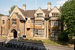
The Department of Social Policy and Intervention is an interdisciplinary centre for research and teaching in social policy and the systematic evaluation of social intervention based in the Social Sciences Division of the University of Oxford. It dates back to Barnett House, a social reform initiative founded in 1914 by a reform movement clergyman, Samuel Barnett (known as Canon Barnett), becoming a department of Oxford in 1961.The department hosts two main research units: the Oxford Institute of Social Policy (OISP) and the Centre for Evidence-Based Social Intervention (CEBI). In 2021 Professor Jane Barlow followed Professor Bernhard Ebbinghaus as head of department.

Excerpt from the Wikipedia article Department of Social Policy and Intervention (License: CC BY-SA 3.0, Authors).

Department of Social Policy and Intervention
Mansfield Road, Oxford City Centre

Geographical coordinates (GPS) Address Nearby Places
placeShow on map

Wikipedia: Department of Social Policy and InterventionContinue reading on Wikipedia

Geographical coordinates (GPS)

Latitude Longitude
N 51.755875 ° E -1.251386 °
placeShow on map

Address

Mansfield Road 3
OX1 3TB Oxford, City Centre
England, United Kingdom
mapOpen on Google Maps

Share experience

Nearby Places

Mansfield Road, Oxford

Mansfield Road is a road in central Oxford, England. It runs north-south with two of Oxford University's colleges on it, Mansfield College and Harris Manchester College, and Queen Elizabeth House which houses the Oxford Department of International Development. To the north is South Parks Road and the University's main Science Area. To the south is Holywell Street. Also off this road to the east near its southern end is Jowett Walk, named after Benjamin Jowett, a Master of Balliol College in Victorian times. On the northern corner with Jowett Walk is the former Geography Department of the University, since 2006 the Oxford Department of International Development (No. 3 Mansfield Road). Savile Road is a cul-de-sac to the west with New College School (associated with New College in Holywell Street close by) just to the north. The University Club sports ground, for use by graduate students and University staff, is based on Mansfield Road, and hosts a football team named after the road, Mansfield Road Football Club, playing in the Morrells of Oxford Premier League, and the Mansfield Road Cricket Club, or Oxford University Club Cricket Club (OUCCC).The Oxford University Club Hurriers (OUCH) were formerly known as the Mansfield Road Runners.Halifax House, a social club for people associated with Oxford University, was located to the east of the northern end of Mansfield Road at 8 South Parks Road from 1961. The building has since been demolished to make way for new university science facilities. Evidence of Bronze Age barrows together with later prehistoric and early Roman field systems was found on the site.