Jowett Walk

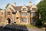
Jowett Walk is a road in central Oxford, England. It connects Mansfield Road to the west with St Cross Road to the east, running parallel with and north of Holywell Street. The road was formerly named Love Lane and used to continue north to South Parks Road on what is now Mansfield Road. It is now named after the well-known Victorian Master of Balliol College, Benjamin Jowett (1817–1893). Much of the land in the area is owned by Balliol College, including the playing fields to the north and student housing.Merton College has a graduate annexe to the south of Jowett Walk at the eastern end. The Oxford Department of International Development is on the corner with Mansfield Road.
Excerpt from the Wikipedia article Jowett Walk (License: CC BY-SA 3.0, Authors, Images).Jowett Walk
Jowett Walk, Oxford City Centre
Geographical coordinates (GPS) Address Nearby Places Show on map
Geographical coordinates (GPS)
| Latitude | Longitude |
|---|---|
| N 51.7555 ° | E -1.2502 ° |
Address
Jowett Walk
Jowett Walk
OX1 3TD Oxford, City Centre
England, United Kingdom
Open on Google Maps


