Parramatta River

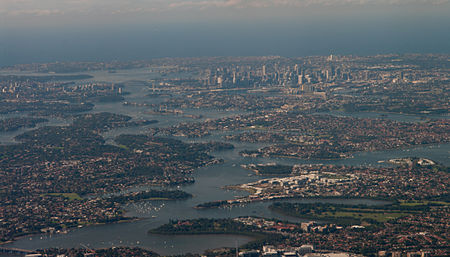
The Parramatta River is an intermediate tide-dominated, drowned valley estuary located in Sydney, New South Wales, Australia. With an average depth of 5.1 metres (17 ft), the Parramatta River is the main tributary of Sydney Harbour, a branch of Port Jackson. Secondary tributaries include the smaller Lane Cove and Duck rivers. Formed by the confluence of Toongabbie Creek and Darling Mills Creek at North Parramatta, the river flows in an easterly direction to a line between Yurulbin in Birchgrove and Manns Point in Greenwich. Here it flows into Port Jackson, about 21 kilometres (13 mi) from the Tasman Sea. The total catchment area of the river is approximately 252.4 square kilometres (97.5 sq mi) and is tidal to Charles Street Weir in Parramatta, approximately 30 kilometres (19 mi) from the Sydney Heads.The land adjacent to the Parramatta River was occupied for many thousands of years by Aboriginal peoples of the Wallumettagal nations and the Wangal, Toongagal (or Tugagal), Burramattagal, and Wategora clans of the Darug people. They used the river as an important source of food and a place for trade. The river was formed 15 to 29 million years ago as its waters began to cut a valley into sandstone and shale.
Excerpt from the Wikipedia article Parramatta River (License: CC BY-SA 3.0, Authors, Images).Parramatta River
Lower Serpentine Road, Sydney Greenwich
Geographical coordinates (GPS) Address Nearby Places Show on map
Geographical coordinates (GPS)
| Latitude | Longitude |
|---|---|
| N -33.844654 ° | E 151.181859 ° |
Address
Lower Serpentine Road
2065 Sydney, Greenwich
New South Wales, Australia
Open on Google Maps


