place

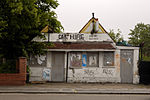
St Matthew's Church, Willesden

1906 establishments in England20th-century Church of England church buildingsAnglo-Catholic churches in England receiving AEOBuildings by W. D. CaröeChurch of England church buildings in the London Borough of Brent
Diocese of LondonEngvarB from September 2019Gothic Revival architecture in LondonGothic Revival church buildings in LondonGrade II listed buildings in the London Borough of BrentGrade II listed churches in LondonWillesden
St Matthew's Church, Willesden by Mike Quinn Geograph 2774482

St Matthew's Church is an Anglican parish church in Willesden in the London Borough of Brent. It is situated on the corner of St Mary's Road and Fawcett Road in Willesden. It was built between 1900 and 1906, designed by W. D. Caröe and is a Grade II listed building. It is in the deanery of Brent, in the archdeaconry of Northolt, in the Diocese of London.

Excerpt from the Wikipedia article St Matthew's Church, Willesden (License: CC BY-SA 3.0, Authors, Images).

St Matthew's Church, Willesden
St Mary's Road, London Harlesden (London Borough of Brent)

Geographical coordinates (GPS) Address External links Nearby Places
placeShow on map

Wikipedia: St Matthew's Church, WillesdenContinue reading on Wikipedia

Geographical coordinates (GPS)

Latitude Longitude
N 51.5417 ° E -0.2489 °
placeShow on map

Address

St Matthew's Church

St Mary's Road
NW10 4AY London, Harlesden (London Borough of Brent)
England, United Kingdom
mapOpen on Google Maps

linkWikiData (Q15979440)
linkOpenStreetMap (80539455)

St Matthew's Church, Willesden by Mike Quinn Geograph 2774482
Share experience

Nearby Places

Harlesden railway station (Midland Railway)

Harlesden railway station was a station in northwest London on the south side of the southern section of a road called Craven Park, which is part of the A404 Harrow Road between Paddington and Wembley. The station was sometimes known as Harrow Road or as Stonebridge Park. It was opened by the Midland Railway on the Dudding Hill Line on 3 August 1875, partly to service the neighbouring exclusive Craven Park Estate. Originally named Harrow Road for Stonebridge Park and West Willesden, the station was renamed several times: on 1 February 1876 it became Harrow Road for Stonebridge Park and Harlesden; on 1 May 1878 Harrow Road; on 1 October 1879 Harrow Road for Stonebridge and Harlesden; on 1 November 1880 Harrow Road for Stonebridge Park and Harlesden; and on 1 July 1884 Stonebridge Park for West Willesden and Harlesden. The station was closed on 2 July 1888.It was reopened on 1 March 1893, and on 1 February 1901 it was renamed again, becoming Harlesden for West Willesden and Stonebridge Park. It was finally closed to passengers for a second time on 1 October 1902, after a sustained campaign by local people. The neighbouring goods sidings were in use for coal deliveries until the 1960s. The street level station buildings were demolished in the 1960s. The former goods office still stood in 2010, although the interior and much of the roof was destroyed in a fire in December 2009. Some platform edges remain, although most were removed when the railway embankment was pinned to stop slippage in 2001. The Dudding Hill Line remains in use for freight services today. The station stood on the later 1855 straightening of this road, which meant the railway had to be built under two roads of the same name. It should not be confused with Harlesden station, an existing Network Rail station, some three or four hundred metres south, served by Bakerloo line and London Overground trains.