place

Newton Corner station
Buildings and structures in Newton, MassachusettsFormer MBTA stations in MassachusettsGreen Line (MBTA) stationsMBTA busRailway stations closed in 1969
Railway stations in Middlesex County, MassachusettsRailway stations in the United States opened in 1834
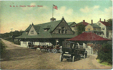
Newton station Souvochrome postcard

Newton Corner was a streetcar and passenger rail station in the Newton Corner neighborhood of Newton, Massachusetts, located near where Washington Street crosses the Massachusetts Turnpike. The Newton Corner station, known simply as Newton for much of its lifetime, served commuters on the Worcester Line (run by the New York Central Railroad and its predecessors) from 1834 to 1959. The trolley stop, located on the surface streets, served a number of routes beginning in 1898, including the Green Line A branch until 1969. Newton Corner is now a stop and transfer point for a number of bus routes including high-frequency express routes to downtown Boston as well as local routes.

Excerpt from the Wikipedia article Newton Corner station (License: CC BY-SA 3.0, Authors, Images).

Newton Corner station
Centre Street, Newton Newton Corner

Geographical coordinates (GPS) Address Nearby Places
placeShow on map

Wikipedia: Newton Corner stationContinue reading on Wikipedia

Geographical coordinates (GPS)

Latitude Longitude
N 42.35756 ° E -71.18441 °
placeShow on map

Address

Centre Street

Centre Street
02172 Newton, Newton Corner
Massachusetts, United States
mapOpen on Google Maps

Newton station Souvochrome postcard
Share experience

Nearby Places

Farlow and Kenrick Parks Historic District

The Farlow and Kenrick Parks Historic District is a predominantly residential historic district in the Newton Corner area of Newton, Massachusetts. The district is roughly triangular in shape, and is bounded on the north by the Massachusetts Turnpike, Park Street to the east, and Franklin and Newtonville Avenues to the west. It is roughly bisected by Church Street, and is named for two parks that are significant focal elements of the district. Kenrick Park is a small lozenge-shaped park at the southern tip of the district designed by Alexander Wadsworth; it was laid out at the request of William Kenrick, a horticulturalist whose c. 1822 Federal style house was moved to the area after the park was completed. Farlow Park is a larger rectangular park in the district's northwest, which was established by a gift from John Farlow. It is landscaped in a manner similar to the Boston Public Garden, with specimen trees and an artificial pond with bridge.The district was one of the first major areas of suburban residential development in Newton, spurred by the railroad station at Newton Corner, and the development of streetcar lines. There was some early development in the 1840s, resulting in a number of Greek Revival and Italianate houses being built in the area, but major development occurred between 1870 and 1910, resulting in a significant number of Queen Anne and Colonial Revival houses. The district includes a number of significant churches: the 1885 Immanuel Baptist Church, designed by H. H. Richardson; the 1897 Newton Methodist Episcopal Church by Cram, Wentworth and Goodhue; and the 1872 Grace Episcopal Church designed by Alexander Rice Esty.The district was listed on the National Register of Historic Places in 1982, and expanded in 1986, adding a section of Park Street near the southern tip of Kenrick Park.