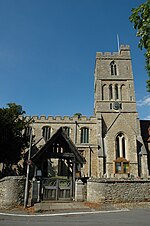
Knotting and Souldrop
Bedfordshire geography stubsBorough of BedfordCivil parishes in BedfordshireUse British English from July 2016
Knotting and Souldrop is a civil parish in the Borough of Bedford in the county of Bedfordshire, England.The two parishes of Knotting and Souldrop were combined in 1934. Until 1974 the parish formed part of Bedford Rural District.
Excerpt from the Wikipedia article Knotting and Souldrop (License: CC BY-SA 3.0, Authors).Knotting and Souldrop
Rushden Road,
Geographical coordinates (GPS) Address Phone number Website Nearby Places Show on map
Geographical coordinates (GPS)
| Latitude | Longitude |
|---|---|
| N 52.25 ° | E -0.542 ° |
Address
Souldrop Turn Filling Station
Rushden Road
MK44 1HJ , Knotting and Souldrop
England, United Kingdom
Open on Google Maps


