Montafon
Pages including recorded pronunciationsPages with German IPASilvretta AlpsValleys of VorarlbergVerwall Alps ... and 1 more
Vorarlberg

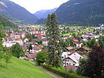
Montafon (German: [mɔntaˈfoːn] in local dialect: "Muntafu") is a 39 km long valley in the westernmost Austrian federal state of Vorarlberg. It is traversed by the river Ill (Vorarlberg) and extends from the city of Bludenz and the Verwall Alps in the north, to the Silvretta and Rätikon mountain range in the south. Piz Buin, at 3,312 meters, is the highest peak within the Silvretta mountain range and the highest peak in Vorarlberg. The Montafon region has a population of 16,421(2021).
Excerpt from the Wikipedia article Montafon (License: CC BY-SA 3.0, Authors, Images).Montafon
Unterschrofenweg,
Geographical coordinates (GPS) Address Nearby Places Show on map
Geographical coordinates (GPS)
| Latitude | Longitude |
|---|---|
| N 47.041944444444 ° | E 9.9516666666667 ° |
Address
Europaschutzgebiet Gortniel
Unterschrofenweg
6791
Vorarlberg, Austria
Open on Google Maps


