place

Philadelphia Charter School for Arts and Sciences

1924 establishments in PennsylvaniaCharter schools in PennsylvaniaColonial Revival architecture in PennsylvaniaNortheast PhiladelphiaPhiladelphia County, Pennsylvania Registered Historic Place stubs
School buildings completed in 1924School buildings on the National Register of Historic Places in Philadelphia
Phila HenryREdmondsSchool01

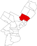
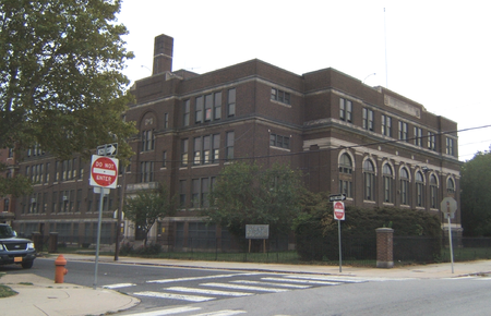
Philadelphia Charter School for Arts and Sciences at H.R. Edmunds is a charter school located in the Northwood neighborhood of Philadelphia, Pennsylvania. It is located in the former Henry R. Edmunds School building. The building was designed by Irwin T. Catharine and built in 1923–1924. It is a three-story, nine-bay, brick building on a raised basement in the Colonial Revival style. It features a projecting entrance pavilion, stone cornice, and brick parapet.It was added to the National Register of Historic Places in 1988.

Excerpt from the Wikipedia article Philadelphia Charter School for Arts and Sciences (License: CC BY-SA 3.0, Authors, Images).

Philadelphia Charter School for Arts and Sciences
Haworth Street, Philadelphia

Geographical coordinates (GPS) Address Phone number Website External links Nearby Places
placeShow on map

Wikipedia: Philadelphia Charter School for Arts and SciencesContinue reading on Wikipedia

Geographical coordinates (GPS)

Latitude Longitude
N 40.0251 ° E -75.087 °
placeShow on map

Address

The Philadelphia Charter School for Arts and Sciences at H.R. Edmunds

Haworth Street 1197
19124 Philadelphia
Pennsylvania, United States
mapOpen on Google Maps

Phone number
String Theory Schools

call+12155372520

Website
stringtheoryschools.org

linkVisit website

linkWikiData (Q5727299)
linkOpenStreetMap (352414116)

Phila HenryREdmondsSchool01
Share experience

Nearby Places

Frankford High School

Frankford High School is a public high school in the School District of Philadelphia. It is located at Oxford Avenue and Wakeling Street in the Frankford section of Northeast Philadelphia, Pennsylvania, United States. Frankford was founded in 1910 as an annex to Central High School. For the school's colors, blue was added to the red and gold of Central. Frankford's slogan is "Home of Champions," a nod to its longstanding tradition of fielding strong sports teams. The school's athletic teams are nicknamed the Pioneers. In the fall of 2018, Frankford High School became Frankford High School Aviation Academy, launching a unique program to provide a career path for the graduates of the program. Beginning with the class of 2022, students have the opportunity to enroll in the Aviation Program. After their completion, they can earn their private pilot license and by the time they are 21 be eligible for their commercial pilot license. The program will also include multiple tracks of study including drone-piloting and airplane mechanic/maintenance.Frankford's soccer team won ten straight Public League Championships (1987–1996), four of which by shutout. Frankford's wrestling team won 11 straight Public League Championships ending in 2007. On May 19, 2010, Principal Reginald Fisher was cited in a report appearing in the Philadelphia newspapers that he was one of 15 administrators not certified to run their schools. Whether this issue has been resolved has not been reported as of present.

Roosevelt Boulevard (Philadelphia)

Roosevelt Boulevard, officially named the Theodore Roosevelt Memorial Boulevard and often referred to, chiefly by local Philadelphians, simply as "the Boulevard," or "the Boully" is a major traffic artery through North and Northeast Philadelphia. The road begins at the Schuylkill Expressway in Fairmount Park, running as a freeway also known as the Roosevelt Boulevard Extension or the Roosevelt Expressway through North Philadelphia, then transitioning into a twelve-lane divided highway that forms the spine of Northeast Philadelphia to its end at the city line. Historically, Roosevelt Boulevard is a part of the Lincoln Highway, the first road across America, which ran for 3,389 miles (5,454 km) from Times Square in New York City to Lincoln Park on the Pacific Ocean in San Francisco, California. Today, Roosevelt Boulevard is designated as US 1 (north of the Roosevelt Expressway), US 13 (between Hunting Park Avenue and Robbins Street), and Pennsylvania Route 63 (between Red Lion and Woodhaven Roads).The road is notorious for two intersections which have been designated the second and third most dangerous intersections in the country by State Farm Insurance, at Red Lion Road and Grant Avenue respectively. The dangerous reputation of the road led to installation of the first red light cameras in Philadelphia in 2004. The road has been the scene of numerous pedestrian casualties and studies are underway to allow pedestrian traffic to be separated from vehicular traffic.