Laleston

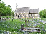
Laleston is a village and a community in Bridgend County Borough, south Wales, directly west of Bridgend town centre. The village takes its name from the Norman Lageles family who settled in the area. Buildings of note in the village include St David's Church, which still possesses features dating back to the 13th and 14th centuries, the Great House which was built in the early 16th century and Horeb Welsh Presbyterian Church (1831). As a community, Laleston includes the areas of Bryntirion, Cefn Glas, Tythegston and Broadlands. The boundaries of the community are almost entirely set by transportation routes, with the western and north western border defined by the M4 motorway, where it then turns south-easterly at Stormy Down following the A48 back towards Bridgend town centre. It then takes in the Greenfields area, briefly following the banks of the River Ogmore, before heading north to Cefn Glas, but skirting Bridgend town centre and Newcastle. At the 2001 census, the community's population was 8,475, increasing to 12,586 at the 2011 Census, a 48.5% increase.
Excerpt from the Wikipedia article Laleston (License: CC BY-SA 3.0, Authors, Images).Laleston
Well Street,
Geographical coordinates (GPS) Address Nearby Places Show on map
Geographical coordinates (GPS)
| Latitude | Longitude |
|---|---|
| N 51.504753 ° | E -3.62259 ° |
Address
Well Street
Well Street
CF32 0LE , Laleston
Wales, United Kingdom
Open on Google Maps


