place

Capitol Peak (Thurston County)

Mountains of Thurston County, WashingtonMountains of Washington (state)Thurston County, Washington geography stubs
Capitol Peak
Capitol Peak

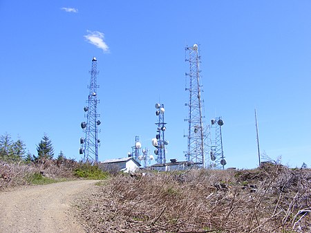
Capitol Peak is a 2,658-foot (810 m) peak in the Black Hills in the U.S. state of Washington. It is one of the two highest peaks in the Black Hills, along with Larch Mountain. Capitol Peak is located in the Capitol State Forest. There is a partially paved road to the summit called the Sherman Valley Road. The summit hosts a communications facility that includes an array of cell phone and radio towers. On a clear day, looking to the west is a view of Elma and the Satsop Nuclear Power Plant. Looking to the east is a view of Mount Rainier, Mount St. Helens, and Mount Adams; more to the north are the Puget Sound, and the Olympia area.: 80 

Excerpt from the Wikipedia article Capitol Peak (Thurston County) (License: CC BY-SA 3.0, Authors, Images).

Capitol Peak (Thurston County)
C-4300,

Geographical coordinates (GPS) Address Nearby Places
placeShow on map

Wikipedia: Capitol Peak (Thurston County)Continue reading on Wikipedia

Geographical coordinates (GPS)

Latitude Longitude
N 46.97273885 ° E -123.138875111 °
placeShow on map

Address

C-4300

C-4300

Washington, United States
mapOpen on Google Maps

Capitol Peak
Capitol Peak
Share experience

Nearby Places

Mima mounds
Mima mounds

Mima mounds are low, flattened, circular to oval, domelike, natural mounds that are composed of loose, unstratified, often gravelly sediment that is an overthickened A horizon. These mounds range in diameter from 3 to more than 50 m; in height 30 cm to greater than 2 m; and in density from several to greater than 50 mounds per hectare, at times forming conspicuous natural patterns. Mima mounds can be seen at the Mima Mounds Natural Area Preserve in Washington state. "Mima" is a name derived from a Chinook Jargon term meaning "a little further along" or "downstream".Theories for the origin of Mima mounds include burrowing by pocket gophers; accumulation of wind-blown (aeolian) sediments around vegetation to form coppice dunes or nebkhas; seismic ground shaking by major earthquakes, though none have been observed to form Mima mounds; and shrinking and swelling of clays in hog-wallow or gilgai landforms. Though the definitive Mima mounds are common in North America, it has not been shown that all North American mounds result from the same causes. Superficially similar phenomena occur on all continents, and the proposed causal factors do not occur in all regions that have been studied. Nor is it clear that all such mounds really are the same, either physically or functionally; for example, the so-called fairy circles of Southern Africa tend to be less mound-like and occur in different climatic and ecological conditions from Mima mounds. Furthermore, it has been argued that the possibly distinct heuweltjies of the South Western Cape region of South Africa are of an origin far different from either.