place

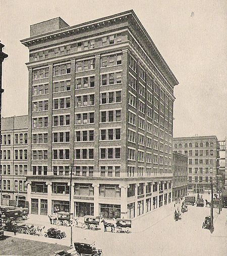
Eaton's Annex

Buildings and structures in TorontoDepartment store buildings in CanadaEaton's
Eatonsannex1919commons

Eaton's Annex was a 10-storey building containing both retail and office space in Downtown Toronto, Ontario, Canada. It opened in January 1913 and was located at the northwest corner of Albert Street and James Street, west of Eaton's Main Store and north of Toronto's (now former) City Hall.

Excerpt from the Wikipedia article Eaton's Annex (License: CC BY-SA 3.0, Authors, Images).

Eaton's Annex
Bay Street, Toronto

Geographical coordinates (GPS) Address Nearby Places
placeShow on map

Wikipedia: Eaton's AnnexContinue reading on Wikipedia

Geographical coordinates (GPS)

Latitude Longitude
N 43.6537 ° E -79.3821 °
placeShow on map

Address

Bell Trinity Square

Bay Street 483
M5H 2N2 Toronto
Ontario, Canada
mapOpen on Google Maps

Eatonsannex1919commons
Share experience

Nearby Places

Old Toronto
Old Toronto

Old Toronto is the part of Toronto, Ontario, Canada, that corresponds to the boundaries of the City of Toronto prior to 1998. It was incorporated as a city in 1834, after being known as the town of York, and being part of York County. Toronto periodically grew in size by annexing adjacent land and municipalities. In 1954, the City of Toronto and the surrounding suburban towns and townships of York County were joined in a federation known as the Municipality of Metropolitan Toronto (Metro). Later, the lower-tier city annexed two towns until it reached its final boundaries in 1967. In 1998, the municipalities of Metro Toronto were amalgamated into the present-day single-tier City of Toronto, which continues legally from the predecessor City of Toronto, although the by-laws of each municipality remained in force. Historically, "Old Toronto" referred to Toronto's boundaries before the Great Toronto Fire of 1904, when most urban development was to the east of Yonge Street. Since the 1998 amalgamation, however, the 1967–1998 area of the lower-tier city is referred to as "Old Toronto" or the "former city of Toronto". It is sometimes less accurately referred to as "downtown" (Downtown Toronto is located within Old Toronto) or as "the core". Old Toronto has a population density of approximately 8,210 residents per square kilometre, which would rank as Canada’s densest (North America's second-densest) city with a population over 100,000 if it were still a distinct city.

York, Upper Canada
York, Upper Canada

York was a town and the second capital of the colony of Upper Canada. It is the predecessor to the old city of Toronto (1834–1998). It was established in 1793 by Lieutenant-Governor John Graves Simcoe as a "temporary" location for the capital of Upper Canada, while he made plans to build a capital near today's London, Ontario. Simcoe renamed the location York after Prince Frederick, Duke of York and Albany, George III's second son. Simcoe gave up his plan to build a capital at London, and York became the permanent capital of Upper Canada on February 1, 1796. That year Simcoe returned to Britain and was temporarily replaced by Peter Russell. The original townsite was a compact ten blocks near the mouth of the Don River and a garrison was built at the channel to Toronto Harbour. Government buildings and a law court were established. Yonge Street was built, connecting York to the Holland River to the north. To the east, Kingston Road was built to the mouth of the Trent River. In 1797, the town site was expanded to the west to allow for public buildings and expansion. One of the new area's public functions, a public market, was started in 1803. It continues today as St. Lawrence Market. The settlement was attacked by American troops during the War of 1812. As the British garrison retreated, they detonated their powder magazine, inflicting numerous casualties on the invading U.S. forces, who proceeded to loot and destroy the town. The victorious Americans chose not to occupy the town and the British eventually returned without conflict. A reprisal attack was made on the American capital of Washington, D.C. a year later. After the war was over, the town continued to grow, expanding to the west, leaving the original town site, a less desirable location, somewhat undeveloped. A new parliament building was erected, near the original location, but this burned down and a new building was built in the new lands to the west. A permanent fort, Fort York, was built on the site of the garrison. Dundas Street was built to connect York to towns to the west. In the 1820s, the town experienced a surge of immigrants, expanding from 1,000 residents to over 9,000 by the time the town was incorporated as the City of Toronto in 1834. During its existence, the town did not have its own government; it was governed by the province of Upper Canada, with a mix of elected officials and an aristocracy known as the Family Compact controlling the government. By 1830, this led to an ongoing political conflict, which would later lead to the 1837 Upper Canada Rebellion.
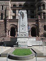
Old City Hall Cenotaph, Toronto

The Old City Hall Cenotaph is a cenotaph located at the front steps of Old City Hall in Toronto, Ontario, Canada.Originally built after World War I to commemorate Torontonians who lost their lives in services for Canada, the memorial also commemorates those who died in World War II and the Korean War. It was modelled on The Cenotaph at Whitehall in London, England, constructed using granite cut from the Canadian Shield, and unveiled on November 11, 1925. The City of Toronto lists the artists as "Ferguson/Pomphrey", which were an architectural firm located at 282 St. Clements Ave. in north Toronto. Their design was selected from among 50 designed submitted after City Council's request to replace a temporary wooden structure that had been used each Remembrance Day since 1919. The two Toronto architects received a fee of $2500 for the work; this was 10% of the cost of the $25 000 project. The work was completed in budget and on time. There was some controversy before the monument was unveiled; "the only wording on the Cenotaph would be a simple four word statement “TO ALL WHO SERVED.” Then someone realized that this monument was in fact a cenotaph, a structure that by the very definition of that word (from the Greek kenotaphion – kenos, empty + taphos, tomb) signified an “empty tomb.” " As a memorial to those who had died and are buried elsewhere, it was felt that TO ALL WHO SERVED was inappropriate in such a case. After much discussion, the original inscription was removed and replaced with the current TO OUR GLORIOUS DEAD.The memorial features a stone laid by Field Marshall Haig on July 24, 1925.The site is one of several locations used for Remembrance Day commemorations in Toronto.