place

Goadby

Civil parishes in Harborough DistrictLeicestershire geography stubsUse British English from July 2015Villages in Leicestershire
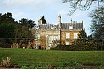
St John the Baptist church, Goadby, Leics geograph.org.uk 147921

Goadby is a village and civil parish in the Harborough district of Leicestershire, England, about 8 miles north of Market Harborough. It had a population of 204 according to the 2011 census.The village's name means 'farm/settlement of Gauti'.Goadby has a Church of England Parish church, St. John the Baptist, which is of 13th-century origin. The church was extensively renovated in the 19th century. Services are held on the first Sunday of every month. The church is part of a group of churches ministered to from Billesdon. Every year, a fundraising fete is held in Goadby on the Saturday of the August Bank Holiday weekend to provide funds for the Church. Goadby has no industry, and is notable chiefly for its stud farm, at which the celebrated race horse Desert Orchid was foaled. Goadby's name, with the "-by" suffix, indicates that it is of Danish origin. Goadby is recorded in the Domesday Book as "Goutebi". "Goadby, Leicester, is a chapelry in Billesdon parish near a branch of the river Welland. This is annexed to the vicarage of Billesdon, in the diocese of Peterborough. The church was restored in 1854." One of the current residents of Goadby is Kev Burgess, Racing Manager for Diamond Racing, the syndicate that owns 2021 Welsh Grand National and 2023 Classic Chase Winner, Iwilldoit.

Excerpt from the Wikipedia article Goadby (License: CC BY-SA 3.0, Authors, Images).

Goadby
Palmers Lane, Harborough Goadby

Geographical coordinates (GPS) Address Nearby Places
placeShow on map

Wikipedia: GoadbyContinue reading on Wikipedia

Geographical coordinates (GPS)

Latitude Longitude
N 52.583333 ° E -0.883333 °
placeShow on map

Address

Palmers Lane

Palmers Lane
LE7 9WB Harborough, Goadby
England, United Kingdom
mapOpen on Google Maps

St John the Baptist church, Goadby, Leics geograph.org.uk 147921
Share experience

Nearby Places

Glooston
Glooston

Glooston is a small village and civil parish in the Harborough district of Leicestershire, England. According to the 2001 census the parish had a population of 54, increasing to 147 (including Cranoe and Stonton Wyville) at the 2011 census.The village's name means 'farm/settlement of Glor'.The parish covers an area of 973 acres (3.94 km2) or 1.46 square miles (3.8 km2). Its shape is long and narrow, being over 2 miles (3.2 km) in length north to south. The highest point in the parish is Crossburrow Hill, 400 feet (120 m) high. The settlement of Glooston lies around a crossroads in the centre of the parish. There are several 17th- and 18th-century brick-built houses, and a terrace of early 19th-century stone-built cottages. The Roman Gartree Road crosses the village east to west and the site of a Roman villa, by a stream north-east of the crossroads, was excavated in 1946. The manor of Glooston was recorded in the Domesday Book of 1086 as being held by Hugh de Grentemesnil. From 1180 to the middle of the 14th century the Basset family of Drayton were mesne tenants. The manor was held of the Bassets by the Harington family, and from c. 1412-1422 held by the Brauncepath family, through the marriage of Margaret Harington to Richard Brauncepath. The manor passed to John Colly, a distant Harington relative, in 1480 after a protracted legal dispute. His descendant Anthony Colly put the manor in trust in 1587 to pay an annuity of £100 for 60 years to a skinner, Randall Manning of London. This payment was in arrears by 1592, and possession of the manor passed to Manning. In 1614 Colly redeemed it for £1,500, and in 1632 he sold it to the Brudenell family for £4,500, in whose possession it has remained. By the 17th century half of the agricultural land in the parish (to the north of the village) was enclosed and laid down to pasture as sheep runs. To the south of the village were three open fields, Little Field, Burrough or Crosborough Field, and Willowsike Field. These were enclosed in 1828, with a total area of 469 acres (1.90 km2) being allotted. The lord of the manor, the Earl of Cardigan, who held the whole of the old enclosures, was allotted 56 acres (230,000 m2). The Rev. J. H. Dent of Hallaton, whose family held an estate in Glooston, was allotted 236 acres (0.96 km2). The Rector of Glooston was allotted 182 acres (0.74 km2) in lieu of tithes and glebe. The parish church of St John the Baptist was rebuilt in 1866-67 by the architect Joseph Goddard of Leicester. Goddard appears to have retained the plan of the original church, whose fabric was mostly of 15th- or 16th-century date. It has an aisleless nave, chancel, south porch and a double bell-cote.

Hallaton Treasure
Hallaton Treasure

The Hallaton Treasure, the largest hoard of British Iron Age coins, was discovered in 2000 near Hallaton in southeast Leicestershire, England, by volunteers from the Hallaton Fieldwork Group. The initial find was made by Ken Wallace on 19 November 2000, when he found about 130 coins with a metal detector.Along with local community archaeologists, the University of Leicester Archaeological Services (ULAS) excavated what turned out to be one of the most important Iron Age excavations and community archaeology projects in Britain.The hoard includes over 5,000 silver and gold coins, a silver-gilt Roman parade helmet, jewellery, and other objects. Most of the items date to around the time of the Roman conquest of Britain in the 1st century AD. Of the coins from the site, 4,835 can be attributed to the local Celtic tribe, the Corieltauvi. This find more than doubled the total number of Corieltauvian coins already recorded. A silver Roman coin from the hoard has been dated by local museums to 211 BC, and is the oldest Roman coin found in Britain.Some archaeologists have however speculated that it found its way into Britain before the Roman conquest in 43 AD and is evidence of exchange through trade or diplomacy. The site of the treasure proved to be an internationally important ritual site dating mostly to the generations before and after the Roman conquest. Archaeologists believe that the site is a type of open-air shrine that is the first of its kind to have been discovered in the UK. It was located on a hilltop in the Welland valley and was probably enclosed by a ditch and palisade.According to Professor David Mattingly, an archaeologist with the University of Leicester, "This hoard has changed our view of just how significant the East Midlands were in this period and this coin is a good example. It indicates there was contact between this region and the Roman Empire despite the distance between the East Midlands and the parts of Britain the Romans arrived in, like Colchester and Chichester."Finds from the Treasure are displayed at Harborough Museum. The Roman Hallaton Helmet underwent nine years of conservation at the British Museum and went on display at Harborough Museum in 2012. In January 2011 it was announced that the skeleton of a dog, believed to have been sacrificed to guard the treasure, would also be displayed at Harborough Museum.In 2012 a silver ring inscribed "TOT" was found in the area that the Hallaton Treasure was discovered. The inscription is believed to refer to the Celtic god Toutatis, corresponding to the Roman god Mars, who Adam Daubney, an expert on this type of ring, suggests may have been worshipped at Hallaton. Leicestershire County Council have acquired the ring for display at the Harborough Museum.