Penton Hook Marina
Geography of the River ThamesMarinas in EnglandSurrey geography stubsUse British English from January 2017

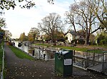
Penton Hook Marina is the largest inland marina in Britain. It is situated on the River Thames in Surrey between Staines and Chertsey on the western bank of the river and is close to Thorpe Park. It is on the reach above Chertsey Lock and opposite Penton Hook Island. The marina is set in 80 acres of what were previously disused gravel pits. It has approximately 600 berths. The marina is downstream from Runnymede where King John signed Magna Carta.
Excerpt from the Wikipedia article Penton Hook Marina (License: CC BY-SA 3.0, Authors, Images).Penton Hook Marina
Staines Road, Borough of Runnymede
Geographical coordinates (GPS) Address External links Nearby Places Show on map
Geographical coordinates (GPS)
| Latitude | Longitude |
|---|---|
| N 51.410277777778 ° | E -0.50555555555556 ° |
Address
Penton Hook Marina (MDL Penton Hook Marina)
Staines Road
KT16 8PY Borough of Runnymede
England, United Kingdom
Open on Google Maps


