place

Haskell, New Jersey

1898 establishments in New JerseyAC with 0 elementsCompany towns in New JerseyPopulated places established in 1898Unincorporated communities in New Jersey
Unincorporated communities in Passaic County, New JerseyWanaque, New Jersey
Manufacturing explosives during World War I at DuPont factory in Haskell, New Jersey

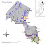
Haskell is an unincorporated community located within Wanaque Borough, in Passaic County, New Jersey, United States. Haskell was formed in 1898 as a company town for a smokeless powder mill of the Laflin & Rand Powder Company. The town was named for Laflin & Rand company president Jonathan Haskell. The Haskell powder mill manufactured the W.A. .30 caliber smokeless powder used in United States Army service rifles until 1908. Laflin & Rand was purchased by DuPont in 1902, and the powder mill ceased operations in 1926. The area is served by the United States Postal Service as part of ZIP Code 07420. The community is located in suburban Northern New Jersey. As of the 2010 United States Census, the population for ZIP Code Tabulation Area 07420 was 4,942.

Excerpt from the Wikipedia article Haskell, New Jersey (License: CC BY-SA 3.0, Authors, Images).

Haskell, New Jersey
2nd Avenue,

Geographical coordinates (GPS) Address Nearby Places
placeShow on map

Wikipedia: Haskell, New JerseyContinue reading on Wikipedia

Geographical coordinates (GPS)

Latitude Longitude
N 41.028333333333 ° E -74.296111111111 °
placeShow on map

Address

CVS

2nd Avenue
07420 , Haskell
New Jersey, United States
mapOpen on Google Maps

Manufacturing explosives during World War I at DuPont factory in Haskell, New Jersey
Share experience

Nearby Places

Haskell station
Haskell station

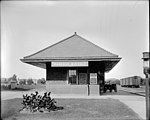
Haskell was a former commuter railroad station in the Haskell section of Wanaque, Passaic County, New Jersey, United States. Located at the Doty Road grade crossing in Wanaque, trains operated on the Erie Railroad's New York and Greenwood Lake Railway between Pavonia Terminal in Jersey City and Wanaque–Midvale station. The next station to the north was Wanaque–Midvale while the next station to the south from c. 1909–1930 was Pompton Junction. Afterwards, the next stop was Pompton–Riverdale. Haskell station consisted of a single low-level side platform and a three-sided shelter for protection.Rail service in Haskell began on January 1, 1873 with the introduction of the Montclair Railway between Pavonia Terminal and Monks station in West Milford. However, Haskell was not an original station, with the two stops in Wanaque being at the crossing of modern County Route 511 known as Wanaque and the station in Midvale. With the establishment of a workers community for the DuPont smokeless powder plant in Wanaque, rail service began operating a stop known as Haskell c. 1909. In 1913, after some political wrangling, the Erie were forced to build a proper station depot, which came in 1916. Just 34 years later, fighting began between Wanaque and the railroad about demolishing the depot, resulting in a fight between August 1950 and March 1952, when the sides agreed to a deal. The railroad replaced the stucco station depot with a three-sided station shelter from Harrison. Service ended on September 30, 1966.

Patriots' Path
Patriots' Path

The Patriots' Path is a multi-use trail system in Morris County, New Jersey, open to cyclists, hikers, and horseback riders, consisting of a 55-mile main trail with 35 miles of spur trails. The main trail is marked with white blazes or a white circular blaze with a brown tree. The spur trails are marked with blue blazes or a white circle with a blue tree, while the side spur trails are marked with a red blaze or a white circle with a red tree.Patriots' Path stretches from East Hanover, where it connects with the Lenape Trail in Essex County, to Allamuchy Mountain State Park in Sussex County, and the Village of High Bridge in Hunterdon County. In southern Morris County, the path travels mostly along the corridors of the Whippany River, Black River, and Raritan River. Different portions of Patriots' Path include bike trails (paved), cross-country skiing, equestrian trails, and hiking trails (handicap accessible). Parts of the trail are along the right of way of the former Rockaway Valley Railroad.The Patriots’ Path is a part of two other larger trail systems. It is included in the Liberty–Water Gap Trail and the September 11th National Memorial Trail. The Liberty–Water Gap Trail is approximately 150 miles and the September 11th National Memorial Trail is 1300 miles long. The Patriots’ Path is a popular location for scouts to complete their Eagle Project. Some of the Eagle Projects that scouts have completed on the Patriots’ Path include installing benches, extending the trail and installing proper signage, and trail renovation and beautification. A particularly popular project to complete is installing a footbridge on the trail.