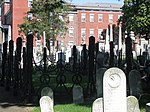
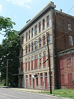
The Shockoe Hill Burying Ground Historic District, located in the city of Richmond, Virginia, is a significant example of a municipal almshouse-public hospital-cemetery complex of the sort that arose in the period of the New Republic following disestablishment of the Anglican Church. The District illustrates changing social and racial relationships in Richmond through the New Republic, Antebellum, Civil War, Reconstruction, and Jim Crow/Lost Cause eras of the nineteenth and twentieth centuries. The Shockoe Hill Burying Ground Historic District occupies 43 acres (17 ha) of land bounded to the south by E. Bates Street, to the north by the northern limit of the Virginia Passenger Rail Authority (previously the CSX rail line) right-of-way (City of Richmond parcel #N0000233022) at the southern margin of the Bacon's Quarter Branch valley, to the west by 2nd Street, and to the east by the historic edge of the City property at the former location of Shockoe Creek. The District encompasses most of a 28.5-acre (11.5 ha) tract acquired by the city of Richmond in 1799 to fulfill several municipal functions, along with later additions to this original tract.The Shockoe Hill Burying Ground Historic District was listed on the Virginia Landmarks Register on March 17, 2022. The district features a suite of municipal functions and services concerned with matters of public welfare, health, and safety, which the City of Richmond relegated to its then-periphery on its northern boundary during the nineteenth century. It includes three properties which have long been recognized and celebrated, that are individually listed on the Virginia Landmarks Register and the National Register of Historic Places: the Almshouse, Shockoe Hill Cemetery, and Hebrew Cemetery. It additionally includes three newly identified sites: the City Hospital and Colored Almshouse Site, the City Powder Magazine Site, and the Shockoe Hill African Burying Ground. The district was also the site of the city gallows. On June 16, 2022 the Shockoe Hill Burying Ground Historic District was added to the National Register of Historic Places.
The Shockoe Hill African Burying Ground is likely the largest burial ground for free people of color and the enslaved in the United States. It is conservatively estimated that over 22,000 people of African descent were buried in its 31 acres (13 ha). It was opened in 1816, and closed in 1879 due to overcrowded conditions. It has suffered many abuses, and was purposely made to disappear from the visible landscape. It is one of "Virginia's most endangered historic places". Current threats to the burial ground include the DC2RVA passenger rail project (high-speed rail), the east-west Commonwealth Corridor, and the proposed widening of I-64, along with various infrastructure projects.


