Rozelle Bay
Bays of New South WalesInner WestSydney HarbourSydney geography stubsUse Australian English from August 2013

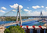
Rozelle Bay is a bay located to the south of Glebe Island and the west of Blackwattle Bay, on Sydney Harbour. The naming of the bay is derived from either the Rosella bird or the Rosella plant, with the latter being more likely, due to the other names in the area that have botanic origins.A light rail station on the Dulwich Hill Line is named after the bay. Rozelle Bay is fed by Johnstons Creek and Whites Creek. The dockyard of the Sydney Heritage Fleet is located on the western shore of Rozelle Bay.
Excerpt from the Wikipedia article Rozelle Bay (License: CC BY-SA 3.0, Authors, Images).Rozelle Bay
Sommerville Road, Sydney Rozelle
Geographical coordinates (GPS) Address Nearby Places Show on map
Geographical coordinates (GPS)
| Latitude | Longitude |
|---|---|
| N -33.866666666667 ° | E 151.18333333333 ° |
Address
Sydney Metro Construction Parking
Sommerville Road
2039 Sydney, Rozelle
New South Wales, Australia
Open on Google Maps


