Glebe Island
Glebe, New South WalesIslands of SydneySydney localities

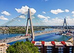
Glebe Island was a major port facility in Sydney Harbour and, in association with the adjacent White Bay facility, was the primary receiving venue for imported cars and dry bulk goods in the region until 2008. It is surrounded by White, Johnstons, and Rozelle Bays. Whilst retaining its original title as an "island", it has long been infilled to the shoreline of the suburb of Rozelle and connected by the Glebe Island Bridge (and its replacement the Anzac Bridge) to Pyrmont.
Excerpt from the Wikipedia article Glebe Island (License: CC BY-SA 3.0, Authors, Images).Glebe Island
Sommerville Road, Sydney Rozelle
Geographical coordinates (GPS) Address Nearby Places Show on map
Geographical coordinates (GPS)
| Latitude | Longitude |
|---|---|
| N -33.867 ° | E 151.184 ° |
Address
Sydney Metro Construction Parking
Sommerville Road
2039 Sydney, Rozelle
New South Wales, Australia
Open on Google Maps


