place

Bourne Festival

2002 establishments in EnglandAnnual events in the United KingdomBourne, LincolnshireMusic festival stubsMusic festivals established in 2002
Music festivals in LincolnshireTourist attractions in Lincolnshire
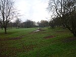
Wellhead Field 2006 geograph.org.uk 723828

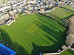
Bourne Festival is an annual music event held in Wellhead Park in the market town of Bourne, Lincolnshire, England. The festival is a charity event organised by Bourne and District Round Table 896, a member of the National Association of Round Tables of Great Britain and Ireland. It was first held in 2002 in celebration of the Queen's Golden Jubilee, and was originally a collaboration between The Queen's Golden Jubilee Committee and Bourne Round Table, reviving the previously held '999 Galas'. The Bourne and District Round Table has run the festival with the help of volunteers as an annual event on the first weekend following the Spring Bank Holiday. Since the first festival in 2002, more than £250,000 has been raised for local and national charities, and individuals.The Festival includes live music from all genres. The headlining acts have included Doctor and the Medics. Since 2010 the event has included a battle of the bands competition for up-and-coming talent under the age of 18.

Excerpt from the Wikipedia article Bourne Festival (License: CC BY-SA 3.0, Authors, Images).

Bourne Festival
South Street, South Kesteven Bourne

Geographical coordinates (GPS) Address Nearby Places
placeShow on map

Wikipedia: Bourne FestivalContinue reading on Wikipedia

Geographical coordinates (GPS)

Latitude Longitude
N 52.766 ° E -0.379 °
placeShow on map

Address

Wellhead Cottage

South Street 17
PE10 9LY South Kesteven, Bourne
England, United Kingdom
mapOpen on Google Maps

Wellhead Field 2006 geograph.org.uk 723828
Share experience

Nearby Places

Bourne Eau
Bourne Eau

Bourne Eau is a short river which rises from an artesian spring in the town of Bourne in Lincolnshire, England, and flows in an easterly direction to join the River Glen at Tongue End. Within the town, it once powered three water mills, one of which is now a heritage centre. At Eastgate, it becomes much wider as it was navigable in the 18th and 19th centuries, and this was the location of the terminal basin. Below the town it is an embanked river, as its normal level is higher than that of the surrounding Fens. Navigation ceased in the 1860s and the river now forms an important part of the drainage system that enables the surrounding fen land to be used for agriculture. The artesian spring is fed by a limestone aquifer, which has been extensively used to supply drinking water to the locality and to Spalding. After a period of low rainfall in the late 1980s, the spring and hence the upper river dried up completely. A remediation project was implemented in 1992/93 to repair wild boreholes, where artesian water was uncontrollably running to waste. 30 boreholes were plugged or repaired, and water returned to the spring and river. The river divides North Fen from South Fen. Both were enclosed in the 1770s, and surplus water from the North Fen was fed to the South Forty-Foot Drain. Steam pumping was introduced in 1845, and the drainage is the responsibility of the Black Sluice Internal Drainage Board (IDB). To drain the South Fen Gilbert Heathcote's tunnel was constructed to take water under the River Glen to the Counter Drain. Various engines were used to pump water through the tunnel, but after the failure of a gas engine in 1942, a new pumping station was built, to pump water into the River Glen. Drainage in the South Fen is now the responsibility of the Welland and Deepings IDB.