Saint-Paul Asylum, Saint-Rémy (Van Gogh series)

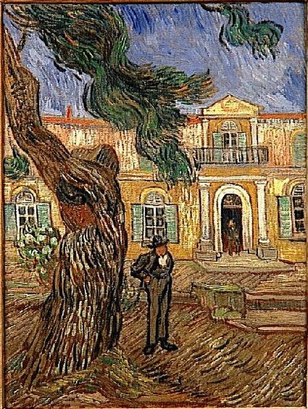
Saint-Paul Asylum, Saint-Rémy is a collection of paintings that Vincent van Gogh made when he was a self-admitted patient at the Saint-Paul asylum in Saint-Rémy-de-Provence, since renamed the Clinique Van Gogh, from May 1889 until May 1890. During much of his stay there he was confined to the grounds of the asylum, and he made paintings of the garden, the enclosed wheat field that he could see outside his room and a few portraits of individuals at the asylum. During his stay at Saint-Paul asylum, Van Gogh experienced periods of illness when he could not paint. When he was able to resume, painting provided solace and meaning for him. Nature seemed especially meaningful to him, trees, the landscape, even caterpillars as representative of the opportunity for transformation and budding flowers symbolizing the cycle of life. One of the more recognizable works of this period is The Irises. Works of the interior of the hospital convey the isolation and sadness that he felt. From the window of his cell he saw an enclosed wheat field, the subject of many paintings made from his room. He was able to make but a few portraits while at Saint-Paul. Within the grounds he also made paintings that were interpretations of some of his favorite paintings by artists that he admired. When he could leave the grounds of the asylum, he made other works, such as Olive Trees (Van Gogh series) and landscapes of the local area. Van Gogh's Starry Night over the Rhone and The Irises were exhibited at the Société des Artistes Indépendants on 3 September 1889, and in January 1890 six of his works were exhibited at the seventh exhibition of Les XX in Brussels. Sadly, just as Van Gogh's work was gaining interest in the artistic community, he was not well enough to fully enjoy it.
Excerpt from the Wikipedia article Saint-Paul Asylum, Saint-Rémy (Van Gogh series) (License: CC BY-SA 3.0, Authors, Images).Saint-Paul Asylum, Saint-Rémy (Van Gogh series)
Chemin des Carrières, Arles
Geographical coordinates (GPS) Address Nearby Places Show on map
Geographical coordinates (GPS)
| Latitude | Longitude |
|---|---|
| N 43.7765 ° | E 4.8334 ° |
Address
Chemin des Carrières
Chemin des Carrières
13210 Arles
Provence-Alpes-Côte d'Azur, France
Open on Google Maps


