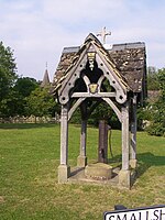
Betchworth
Civil parishes in SurreyEngvarB from June 2016Mole ValleyVillages in Surrey

Betchworth is a village and civil parish in the Mole Valley district of Surrey, England. The village centre is on the north bank of the River Mole and south of the A25 road, almost 3 miles (4.8 km) east of Dorking and 3 miles (4.8 km) west of Reigate. London is 19.5 miles (31.4 km) north of the village. Service sector occupations dominate Betchworth's economy – its station and road links make it a part of the London commuter belt – combined with crop agriculture and services for a relatively large retired proportion of the population. A former lime quarry, rebuilt manor house and Grade I-listed church are within its boundaries.
Excerpt from the Wikipedia article Betchworth (License: CC BY-SA 3.0, Authors, Images).Betchworth
The Street, Mole Valley Betchworth
Geographical coordinates (GPS) Address Nearby Places Show on map
Geographical coordinates (GPS)
| Latitude | Longitude |
|---|---|
| N 51.233 ° | E -0.266 ° |
Address
The Street
The Street
RH3 7DP Mole Valley, Betchworth
England, United Kingdom
Open on Google Maps


