Agden, Cheshire West and Chester

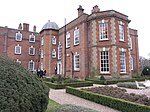
Agden is a small civil parish in the unitary authority of Cheshire West and Chester and the ceremonial county of Cheshire, England. It is the site of Agden Hall. The parish has a parish meeting rather than a parish council. The area is mostly made up of farmland, with just a small population now having residence in the area. At the 2001 census it had a population of 42, compared to a peak of 98 reported in 1851.Agden is located just 3 miles outside of the market town Whitchurch, and 2.5 miles from Malpas. In 1870, John Marius Wilson's Imperial Gazetteer of England and Wales described Agden "a township in Malpas parish, Cheshire; 3 miles NW of Whitchurch. Acres, 548. Real property, £699. Pop., 110. Houses, 21"
Excerpt from the Wikipedia article Agden, Cheshire West and Chester (License: CC BY-SA 3.0, Authors, Images).Agden, Cheshire West and Chester
Agden House Lane,
Geographical coordinates (GPS) Address Nearby Places Show on map
Geographical coordinates (GPS)
| Latitude | Longitude |
|---|---|
| N 52.992 ° | E -2.729 ° |
Address
Agden House Lane
Agden House Lane
SY13 4RH , Agden
England, United Kingdom
Open on Google Maps


