Thorley Street
Isle of Wight geography stubsVillages on the Isle of Wight
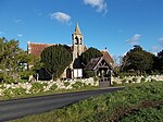
Thorley Street is a village on the Isle of Wight. It is located four kilometres from Totland in the northwest of the island. It is in the civil parish of Shalfleet.
Excerpt from the Wikipedia article Thorley Street (License: CC BY-SA 3.0, Authors).Thorley Street
Main Road,
Geographical coordinates (GPS) Address Nearby Places Show on map
Geographical coordinates (GPS)
| Latitude | Longitude |
|---|---|
| N 50.695277777778 ° | E -1.4661111111111 ° |
Address
Main Road 16
PO41 0SU
England, United Kingdom
Open on Google Maps


