place

Bulstake Stream

Geography of OxfordRivers of OxfordshireThames drainage basinUse British English from January 2017
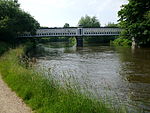
Oxford, Bulstake Stream, New Botley geograph.org.uk 67674

Bulstake Stream, also spelt Bullstake Stream, is a backwater of the River Thames at Oxford, England. The stream leaves the main stream of the Thames at a river junction known as Four Rivers, at the south west corner of Fiddler's Island opposite Sheepwash Channel. It immediately flows past Tumbling Bay, which had a bathing place in use from 1853 to 1990, when the toilets and huts were removed. The pool is still in occasional use, though in disrepair. A fish race was added in to bypass the bathing place and was completed by 2020. The Osney Ditch flows out of the stream southeast towards Osney. The stream follows a semi-circular course, west and then south, passing under bridges on Binsey Lane and Botley Road (Bulstake Bridge) to a confluence with Seacourt/Hinksey Stream near North Hinksey. It resumes, east, past Osney Mead Industrial Estate, and rejoins the Thames at the Osney Rail Bridge. The Thames Path crosses the stream on a bridge known as Boney's Bridge. Botley Stream flows into it from Seacourt Stream just north of Botley Road. The lower part (resumption) is also known as Potts Stream or Pot Stream.Until 1790, the stream was the main navigation channel of the Thames. It became a backwater when Osney Lock was opened.

Excerpt from the Wikipedia article Bulstake Stream (License: CC BY-SA 3.0, Authors, Images).

Bulstake Stream
Boney's Bridge, Oxford South Oxford

Geographical coordinates (GPS) Address Nearby Places
placeShow on map

Wikipedia: Bulstake StreamContinue reading on Wikipedia

Geographical coordinates (GPS)

Latitude Longitude
N 51.7462 ° E -1.2675 °
placeShow on map

Address

Boney's Bridge

Boney's Bridge
OX2 0EW Oxford, South Oxford
England, United Kingdom
mapOpen on Google Maps

Oxford, Bulstake Stream, New Botley geograph.org.uk 67674
Share experience

Nearby Places

Osney Cemetery
Osney Cemetery

Osney Cemetery (also known as Osney St Mary Cemetery) is a disused Church of England cemetery in Osney, west Oxford, England. Its entrance is in Osney Lane, which runs off the south end of Mill Street, south of Botley Road and near the site of Osney Abbey. It borders the Cherwell Valley Line railway a short distance south of Oxford railway station. The cemetery was established in Oxford in 1848, along with Holywell Cemetery and St Sepulchre's Cemetery, because central Oxford churchyards were becoming full. In 1855, new burials were forbidden at all Oxford city churches, apart from in existing vaults. Each of these three new parish cemeteries provided an extension to the churchyards for a specific group of nearby churches, with each church having its own area. Osney Cemetery covered the four ancient parishes of St Aldate's, St Ebbe’s, St Peter-le-Bailey, and St Thomas, and the new parish of Holy Trinity, which had been taken out of St Ebbe’s parish in 1845. The burials in Osney Cemetery are recorded in the parish register for each of these churches just as if they had taken place in its actual churchyard. From 1872 the dead of the new church of St Frideswide, whose parish had been taken out of that of St Thomas, were also buried in Osney Cemetery. Christ Church was still an extra-parochial non-royal peculiar (exempt from the jurisdiction of the diocese) when Osney Cemetery opened, but by 1901 it had been given space in the St Thomas's section of Osney Cemetery called "Christ Church portion”. The entrance to Osney Cemetery has a lych gate.The cemetery contains 26 Commonwealth war graves from the First World War and also one British soldier killed in the Second World War.The cemetery is now closed to new burials. It is still a large green space in central Oxford. In 2006 it was proposed to plant more native trees in the area.