place

Salzachgeier

Kitzbühel AlpsKitzbühel DistrictMountains of Salzburg (state)Mountains of Tyrol (state)Mountains of the Alps
Two-thousanders of AustriaWald im Pinzgau
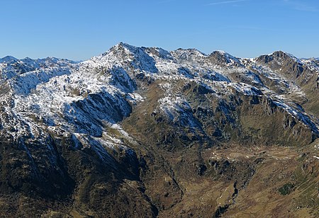
Salzachgeier von Osten

The Salzachgeier (2,469 m above sea level (AA)) is a rugged peak on the edge of the Kitzbühel Alps on the border of the Austrian states of Salzburg and Tyrol. In the cirques and high alpine meadows (Hochalmen) of its eastern slopes and the two neighbouring peaks of Fünfmandling (2,401 m) and Schwebenkopf (2,354 m) are the headstreams of the Salzach, the largest river north of the Salzburg Central Alps. The Salzachgeier has a double summit where five sharp ridges run together. The eastern summit is only three metres lower and towers immediately above the aforementioned source regions (the Salzachboden and Schwebenalm). Whilst the southern slopes of the three peaks descend towards the Gerlos Pass, the watershed to the north (the Salzachjoch 1,983 m) is only a kilometre from the eastern cirques. Here on the state border, high over the Roßwildalm, is a mountain chapel, the Markkirchl (St. Mark's Chapel) and somewhat lower down is the New Bamberg Hut run by the German Alpine Club (DAV). To the west, the slopes are just as steep, but less rocky, and drain into the Frommbach stream in the direction of Kitzbühel. The Salzachgeier is part of the touring area for the Bamberg Hut and is a popular ski tour in winter.

Excerpt from the Wikipedia article Salzachgeier (License: CC BY-SA 3.0, Authors, Images).

Salzachgeier
Gemeinde Wald im Pinzgau

Geographical coordinates (GPS) Address Nearby Places
placeShow on map

Wikipedia: SalzachgeierContinue reading on Wikipedia

Geographical coordinates (GPS)

Latitude Longitude
N 47.293642 ° E 12.103502 °
placeShow on map

Address

Gemeinde Wald im Pinzgau


5742 Gemeinde Wald im Pinzgau
Salzburg, Austria
mapOpen on Google Maps

Salzachgeier von Osten
Share experience

Nearby Places

Torhelm
Torhelm

At a height of 2,494 m (AA) the Torhelm is one of the highest mountains in the Kitzbühel Alps in the Austrian state of Tyrol. It lies at the head of several side valleys of the Ziller and Brixental valleys. Northwest of the summit is the Hemergrund the head of the Märzengrund, a side valley of the Ziller. The Wilde Krimml stream to the southwest drains via the Krummbach and the Gerlos valley into the Ziller valley, whilst the Lange Grund to the northeast runs via the Kelchsau into the Brixental. One of the neighbouring peaks of the Torhelm is the Kreuzjoch (2,558 m). Many ski tourists visit the Torhelm, especially in the spring, although it is one of the mountains within the Kitzbühel Alps to which the longest ski tours go. Normally it is possible to ski downhill well into the valley on firn until the end of May. In summer the Torhelm is accessible on hiking trails from the Wilder Krimml and the Langer Grund. On the summit of the Torhelm is a large summit cross made of wood that was erected in 1978. On a bronze plaque is the following inscription:"Schlag ein wenn eine Hand sich gibt, denn Vorsicht braucht es nicht. Der Mensch der seine Berge liebt ist immer grad und schlicht" ("Take it when his hand is offered, for you need not be cautious. The man who loves his mountains is always straight and true.") Not far away (on the other side of the Gerlos valley) is another mountain also called the Torhelm, which is a smaller neighbour of the Brandberger Kolm.