place

Bulla Bridge

1869 establishments in AustraliaAustralian bridge (structure) stubsBridges completed in 1869Buildings and structures in the City of HumeRoad bridges in Victoria (state)
Stone arch bridges in AustraliaStone bridges in AustraliaTransport in the City of HumeUse Australian English from May 2012Victoria (state) building and structure stubs
Bulla Bridge
Bulla Bridge

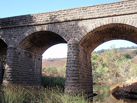
Bulla Bridge is a four span bluestone arched bridge over Deep Creek in the town of Bulla, north east of Melbourne. It was constructed in 1869 by McBurnie and Ramsden, for the Shire of Bulla to a design of Scottish-born engineer John C Climie and replaced a timber bridge built in about 1859. The bridge is 126 feet long and comprises four spans each of 27 feet. It is associated with a c.1843 road cutting and early ford which was on the main road to the Victorian gold fields.The picturesque setting has attracted a number of artists and photographers including the woodcut by Eveline Winifred Syme in the 1930s, and numerous historic photographs.

Excerpt from the Wikipedia article Bulla Bridge (License: CC BY-SA 3.0, Authors, Images).

Bulla Bridge
Bulla Road, Melbourne Bulla

Geographical coordinates (GPS) Address Nearby Places
placeShow on map

Wikipedia: Bulla BridgeContinue reading on Wikipedia

Geographical coordinates (GPS)

Latitude Longitude
N -37.6312 ° E 144.8011 °
placeShow on map

Address

Bulla Road

Bulla Road
3428 Melbourne, Bulla
Victoria, Australia
mapOpen on Google Maps

Bulla Bridge
Bulla Bridge
Share experience

Nearby Places

Organ Pipes National Park

The Organ Pipes National Park, abbreviated as OPNP, is a national park located in the Central region of Victoria, Australia. The 121-hectare (300-acre) protected area was established with the focus on conservation of the native flora and fauna, and preservation of the geological features in the Jacksons Creek, a part of the Maribyrnong valley, north-west of Melbourne. It is situated in a deep gorge in the grassy, basalt Keilor Plains.Within Organ Pipes National Park, the valley walls of Jacksons Creek expose Pleistocene volcanic rocks of the New Volcanic Group. These 2.5 to 2.8 million year-old basalt lavas, commonly known as trap rock, fractured during cooling into vertically standing, hexagonal basalt columns. These columns are locally known as the "organ pipes" for which this park is named. Over the last one to two million years, the slow cutting by Jackson Creek of its valley down into the basaltic plains and through the underlying trap rock exposed these geological structures. The bottom of the valley of Jackson Creek also exposes a prehistoric buried creek valley, which is cut into 400 million year-old (Silurian) mudstones and sandstones. The bottom of this buried valley contains ancient creek gravel. Both the ancient river valley and the Silurian sedimentary rock lies buried beneath the basaltic volcanic rocks of the New Volcanic Group. Marine fossils found in the Silurian sedimentary rocks demonstrate that they accumulated beneath a prehistoric ocean.A Friends' group, (the first in Australia) the "Friends of Organ Pipes" (FOOPS), comprising conservation activists to support the efforts of rehabilitation of the OPNP's indigenous flora and fauna, supplemented the work of the Victoria Park system under which the OPNP was declared a National Park. The park's importance to the whole region as a "center for education about the geology, flora and fauna of the Keilor Plains, and the restoration of degraded land" is important. With its inclusion in the IUCN Category III (Natural Monuments) of the United Nations' list of National Parks and Protected Areas, there is a greater recognition of the need to protect or preserve outstanding natural features.