place

Withybrook

Villages in WarwickshireWarwickshire geography stubs
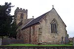
Withybrook Church geograph.org.uk 3837042

Withybrook is a rural village and civil parish in the English county of Warwickshire. Its population was 255 at the 2021 census, increased slightly from 242 at the 2011 census.The village is located in a valley of a small brook, which is a tributary of the River Sowe. It sits just west of the old Fosse Way, about halfway between Nuneaton and Rugby on the B4112 road, and about 7 miles (11 km) north-east of Coventry. Administratively it forms part of the borough of Rugby. The grade II* listed, village church of All Saints, dates from the 14th century. It was extensively restored in 1995. There is a pub in the village called The Pheasant. The village hall has a varied programme of social events throughout the year.About one mile west of the village, is the deserted medieval village of Hopsford.The village came to the attention of the national news in August 2005, when a local farmer Michael Boffey was killed by car thieves who were trying to steal his Land Rover. Two men from Leicester were later convicted of his manslaughter.

Excerpt from the Wikipedia article Withybrook (License: CC BY-SA 3.0, Authors, Images).

Withybrook
Main Street,

Geographical coordinates (GPS) Address Nearby Places
placeShow on map

Wikipedia: WithybrookContinue reading on Wikipedia

Geographical coordinates (GPS)

Latitude Longitude
N 52.45314 ° E -1.36279 °
placeShow on map

Address

Main Street

Main Street
CV7 9LJ
England, United Kingdom
mapOpen on Google Maps

Withybrook Church geograph.org.uk 3837042
Share experience

Nearby Places

Brinklow railway station

Brinklow railway station was a railway station almost midway between Brinklow and Stretton-Under-Fosse in the English county of Warwickshire, opened in 1847 on the Trent Valley Line. Until 1870 it was known as Stretton or possibly Streeton It was also described as Brinklow for Stretton Under Fosse in some timetables. Although line opened in September 1847, full services including those from Brinklow did not begin until 1 December of that year. Initially the station had two platforms, but the traffic along the line was such that an up third line was opened on 14 August 1871. Initially a goods line, it was upgraded in June 1876, when presumably the third platform was added. In 1899 permission was given to quadruple the track between Rugby and Nuneaton. However, with more powerful locomotives coming into use, the work was only partly carried out. The station was next to the B4027 road, with the booking office on the overbridge and covered staircases down to each platform on which passenger facilities were limited to a shelter on the down platform. There were two long sidings, one with a loop which passed through a goods shed.At grouping in 1923 it became part of the London Midland and Scottish Railway. There were six down and five up trains each day in 1895, which had reduced to four down and three up in 1946. The station closed to passengers on 16 September 1957 and for goods on 20 February 1961. There was a signal box which was removed when Rugby Power Signal Box was opened in 1964. The station buildings, platforms and sidings have disappeared, though the entrance road is still present with a barrow crossing which leads to nowhere.

Wolvey
Wolvey

Wolvey is a village and parish in Warwickshire, England. According to the 2011 census it had a population of 1,942, which increased to 2,121 at the 2021 census.The village is located on the Warwickshire/Leicestershire border in an outlying part of the borough of Rugby. The village is, however, more than 11 miles (18 km) north-west from the town of Rugby and closer to Hinckley (five miles to the north), Nuneaton (six miles to the north-west) and Coventry (ten miles south-west). The source of the River Anker is near the highest point in the parish, 130 metres. Originally on the main route between Leicester and Coventry, is now served by the B4065 and B4109 roads. The hamlet of Bramcote forms a western part of the parish, This was the site of a Second World War airfield, RAF Bramcote, subsequently used by the Royal Naval Air Service and renamed HMS Gamecock. Since 1959 it has been used by the army and is known as the Gamecock Barracks. Discoveries of Neolithic flint tools and Bronze Age burial mounds suggest early occupation of the parish while a major Roman road, Watling Street, forms part of the parish boundary. The village certainly existed in Saxon times and the Domesday Survey, compiled in 1086, records 22 households with three further households at Bramcote. By the 12th century there was an additional township, which included a chapel, at the now deserted site of Little Copston (Copston Parva). At this time Wolvey was an important population centre for the area with a weekly market and an annual fair. The village still retains some older buildings including the church of St John the Baptist with its Norman doorway and monumental tombs of Thomas de Wolvey (died 1311) and his wife Alice; also that of Thomas Astley and his wife, Catherine (died 1603). The South Aisle of the church was rebuilt by Thomas de Wolvey's daughter as a memorial Chantry to her husband Sir Giles de Astley who died following the battle of Bannockburn in 1314. The church building has undergone considerable repair and alteration over the years. The chancel was rebuilt in the gothic style by Lord Overstone of Wolvey Grange in the mid-nineteenth century and the present porch to the south door added in 1909. The Millennium Building to the south of the church was built in 2000 to provide important support facilities. The early village would have clustered around the market place (now The Square) but there is little evidence of it in today's buildings.. A staircase dated 1677 in Wolvey Hall reflects the rebuilding of the original house but this was remodelled in 1889. Other late seventeenth century survivals, although modified, include Hollytree Cottage in Wolds Lane and probably 'The Blue Pig' public house with the village pump which will have served as a coaching inn for the Coventry – Leicester traffic in earlier times. The ‘Old Thatched Cottage’ on the edge of The Square dates to the later eighteenth century as does the Baptist Chapel, built in 1789. Essentially a farming community for most of its history, industrialization affected the village in the nineteenth century when knitting and weaving became important trades for a time. There is no evidence to support the popular view that it was a milling centre with 27 windmills. The well-known engraving of four windmills in Wolvey, published in 1854 by Thomas Dugdale, has been shown to be a forgery and was based on an earlier print of windmills on Montmartre, Paris. While rural industry continues, modern housing provides for a commuting population benefiting from the village's proximity to major motorway and rail networks and urban centres. The name Wolvey most probably came from the Anglo-Saxon wulf-hæg or wulf-heg e = "wolf hedge" = "enclosure with a hedge to keep wolves out".

Shilton, Warwickshire

Shilton is a village in the civil parish of Shilton and Barnacle in the English county of Warwickshire. The village is about 5.5 miles (8.9 km) northeast of Coventry on the B4065 road and at a crossroads with the B4029 road, and is the same distance southwest of Hinckley. Administratively, Shilton is in an outlying part of the Borough of Rugby, although it is more than eight miles (13 km) northwest of the town of Rugby. Shilton is almost cut in two by the Trent Valley railway line (part of the West Coast Main Line). The village formerly had its own railway station on this line which opened in 1847, and closed in 1957. A short distance to the northwest of the village is the M69 motorway. The village contains a number of old cottages along the main street which were historically occupied by weavers, a village hall and one old pub, the "Shilton Arms", historically there was a second pub called the "Old Plough".The village was mentioned in the Domesday Book of 1086 as “Scelftone”, and was recorded as having eight households. The parish church of St Andrew's has existed since the 13th century, but was rebuilt twice in the 14th and 15th centuries. A second north aisle was added in 1865, and was designed by Sir George Gilbert Scott. The graveyard has some elaborately carved 18th century gravestones. There is also a small baptist chapel in the village which dates from 1867.Leicester Road is just past the Shilton arms. Leicester Road contains a farm which field lies next to the Shilton Arms garden. As you enter Leicester Road on the left hand side there is a white house which used to be a pub too but was converted into a house in 2002.

Copston Magna
Copston Magna

Copston Magna is a very small village and civil parish in the Rugby borough of Warwickshire, England. It is located around 9 miles (14 km) northwest of the town of Rugby, 6 miles (9.7 km) southeast of Nuneaton. Though it is only 1.5 miles (2.4 km) east of the larger village of Wolvey, Copston Magna was historically part of the parish of Monks Kirby, 3.5 miles (5.6 km) to the south. Copston is located close to the ancient site of High Cross, on the border between Warwickshire and Leicestershire, where the Roman roads of Watling Street and Fosse Way cross each other. In the 2001 Census, the parish had a population of 38. At the 2011 census population details were included with Wolvey. Though the village is often referred to just as "Copston" the name Copston Magna distinguishes the settlement from Copston Parva, an abandoned medieval settlement in Wolvey. Copston first enters the historical record following the Norman Conquest when, in 1077, a priory was established in Monks Kirby. The vill of Copston was part of the endowment given to the new Priory. It is likely that the present Copston church site housed an oratory in the medieval period. Following the Reformation the Earls of Denbigh came to own the land that had belonged to the Priory (see Monks Kirby). The most notable building in Copston Magna today is the Anglican St John's Church built in 1849. Though it is assumed this replaced a medieval chapel, no trace of the older building survives. The church was built by the sisters of Rudolph Feilding, 8th Earl of Denbigh, who opposed the Earl's conversion to Catholicism. It is a grade II* listed building.