place

Addison Road, London

Streets in the Royal Borough of Kensington and ChelseaUse British English from June 2015
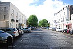
Addison Road, London W14 (geograph 6120003)

Addison Road is a road in London, England, which connects Kensington High Street with Notting Hill and Holland Park Avenue and runs nearby to Holland Park.

Excerpt from the Wikipedia article Addison Road, London (License: CC BY-SA 3.0, Authors, Images).

Addison Road, London
Addison Road, London Notting Hill (Royal Borough of Kensington and Chelsea)

Geographical coordinates (GPS) Address Nearby Places
placeShow on map

Wikipedia: Addison Road, LondonContinue reading on Wikipedia

Geographical coordinates (GPS)

Latitude Longitude
N 51.50246 ° E -0.20932 °
placeShow on map

Address

Addison Road 7
W14 8DJ London, Notting Hill (Royal Borough of Kensington and Chelsea)
England, United Kingdom
mapOpen on Google Maps

Addison Road, London W14 (geograph 6120003)
Share experience

Nearby Places

Addison Avenue
Addison Avenue

Addison Avenue is a street in the Notting Hill area of London. Located in the Royal Borough of Kensington and Chelsea, it runs northwards from Holland Park Avenue to St James's Gardens and St James' Church, crossing Queensdale Road about halfway along. Norland Square is located to its east while Royal Crescent is a little way to the west. A broad, tree-lined avenue, it is largely residential with some commercial properties at the southern end. The smaller Addison Place mews street runs off the western side of the road, looping northwards until it meets Queensdale Road. Addison Avenue is in the wealthy London area of Holland Park.The street, like nearby Addison Road to the south, is named after the early 18th-century writer and politician Joseph Addison who lived at nearby Holland House. The Holland Estate was gradually redeveloped for housing although Addison Avenue was actually built on the adjacent Norland Estate. It was developed during the 1840s by the architect and property developer Robert Cantwell. It was designed with a vista towards St James' Church at the northern end of the street, which was built at the same time.A number of buildings in the street are now Grade II listed, including all those north of Queensdale Road. The houses in the northern part of the street are attributed to F.W. Stent. The street is part of the Norland Conservation Area, designated in 1969. Among the notable former residents was Hugh Carleton Greene (1910–1987), Director-General of the BBC during the 1960s, who is now commemorated by a blue plaque.