Municipal Borough of Erith
Districts abolished by the London Government Act 1963Districts of England created by the Local Government Act 1894History of local government in London (1889–1965)History of the London Borough of BexleyLondon geography stubs ... and 1 more
Municipal boroughs of England

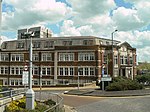
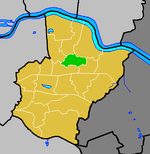
Erith was a local government district in north west Kent from 1876 to 1965 around the town of Erith. It also included the generally suburban areas of Northumberland Heath, Belvedere, and parts of Barnehurst, Bexleyheath, Crayford and the SE2 London Postal District of Abbey Wood.
Excerpt from the Wikipedia article Municipal Borough of Erith (License: CC BY-SA 3.0, Authors, Images).Municipal Borough of Erith
Christchurch Avenue, London Northumberland Heath (London Borough of Bexley)
Geographical coordinates (GPS) Address Nearby Places Show on map
Geographical coordinates (GPS)
| Latitude | Longitude |
|---|---|
| N 51.48 ° | E 0.175 ° |
Address
Christchurch Avenue
Christchurch Avenue
DA8 3AP London, Northumberland Heath (London Borough of Bexley)
England, United Kingdom
Open on Google Maps


