place

Head of Christiana Presbyterian Church

19th-century Presbyterian church buildings in the United StatesBuildings and structures in Newark, DelawareChurches completed in 1859Churches in New Castle County, DelawareChurches on the National Register of Historic Places in Delaware
Irish-American culture in DelawareNational Register of Historic Places in New Castle County, DelawarePresbyterian churches in DelawareScotch-Irish American history
Head of Christiana United Presbyterian Church Apr 10

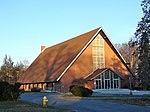
Head of Christiana Presbyterian Church is a historic Presbyterian church and cemetery at 1100 Church Road in Newark, Delaware. It was built in 1859 and is a one-story, four bay gable roofed brick building. Adjacent to the church is a four and a half acre church cemetery with burials dating back to the mid-18th century. The church congregation was established in 1708 by Scotch-Irish immigrants.It was added to the National Register of Historic Places in 1983.

Excerpt from the Wikipedia article Head of Christiana Presbyterian Church (License: CC BY-SA 3.0, Authors, Images).

Head of Christiana Presbyterian Church
West Church Road, Newark

Geographical coordinates (GPS) Address Nearby Places
placeShow on map

Wikipedia: Head of Christiana Presbyterian ChurchContinue reading on Wikipedia

Geographical coordinates (GPS)

Latitude Longitude
N 39.691944444444 ° E -75.786666666667 °
placeShow on map

Address

West Church Road
19711 Newark
Delaware, United States
mapOpen on Google Maps

Head of Christiana United Presbyterian Church Apr 10
Share experience

Nearby Places

Mason–Dixon line
Mason–Dixon line

The Mason–Dixon line, also called the Mason and Dixon line or Mason's and Dixon's line, is a demarcation line separating four U.S. states, forming part of the borders of Pennsylvania, Maryland, Delaware, and West Virginia (part of Virginia until 1863). It was surveyed between 1763 and 1767 by Charles Mason and Jeremiah Dixon as part of the resolution of a border dispute involving Maryland, Pennsylvania, and Delaware in the colonial United States. The dispute had its origins almost a century earlier in the somewhat confusing proprietary grants by King Charles I to Lord Baltimore (Maryland), and by his son King Charles II to William Penn (Pennsylvania and Delaware). The largest portion of the Mason–Dixon line, along the southern Pennsylvania border, later became informally known as the boundary between the Southern slave states and Northern free states. This usage came to prominence during the debate around the Missouri Compromise of 1820, when drawing boundaries between slave and free territory was an issue, and resurfaced during the American Civil War, with border states also coming into play. The Confederate States of America claimed the Virginia portion of the line as part of its northern border, although it never exercised meaningful control that far north – especially after West Virginia separated from Virginia and joined the Union as a separate state in 1863. It is still used today in the figurative sense of a line that separates the Northeast and South culturally, politically, and socially (see Dixie).