place

Ledbury Park

Jewish communities in CanadaNeighbourhoods in TorontoUse Canadian English from January 2023
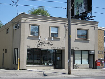
Grodzinski Bakery
Grodzinski Bakery

Ledbury Park is a neighbourhood in Toronto, Ontario, Canada. It is located in the southern part of the North York area, just across the border from Midtown Toronto. Its boundaries are Avenue Road to the east, Lawrence Avenue to the south, Bathurst Street to the West, and Wilson Avenue and Highway 401 to the north. The western boundary of Ledbury Park along Bathurst Street is a predominantly Jewish neighbourhood as many moved from downtown Toronto after World War II.

Excerpt from the Wikipedia article Ledbury Park (License: CC BY-SA 3.0, Authors, Images).

Ledbury Park
Melrose Avenue, Toronto

Geographical coordinates (GPS) Address Nearby Places
placeShow on map

Wikipedia: Ledbury ParkContinue reading on Wikipedia

Geographical coordinates (GPS)

Latitude Longitude
N 43.729 ° E -79.424 °
placeShow on map

Address

Melrose Avenue 470
M5M 4K1 Toronto (North York)
Ontario, Canada
mapOpen on Google Maps

Grodzinski Bakery
Grodzinski Bakery
Share experience

Nearby Places

Asbury & West United Church

Asbury & West United Church is a United Church of Canada church in the Bathurst and Lawrence area of Toronto, Ontario, Canada. The congregation has one of the longest continual histories of any in Toronto. It traces its history back to 1812 and meetings of small groups of Methodist settlers in what was an area being newly settled by Europeans. The first services were held in the farmhouse of Henry Mulholland, a veteran of the War of 1812 and the Battle of Lundy's Lane. He first came to Canada from Ireland in 1806, settling in the area that would later be named Henry Farm after him. He later moved further west to what is now the Bathurst and Lawrence area. The original small congregation was served by circuit preachers who rode out of the small nearby village of Eglinton, Ontario. In 1817 the congregation began to hold services in a new one room schoolhouse. Mulholland began to clear land for a permanent church building, but he died in the 1833 sinking of the Lady of the Lake. His widow, Jane, donated the land that was being cleared to the church, and a small wooden chapel was erected. The church was named after Francis Asbury, an early Methodist leader. This chapel was destroyed by fire in 1898, and a new brick church was built. In 1925 Asbury Methodist joined the United Church of Canada upon its formation, becoming Asbury United Church. In 1947 the church merged with West United Church. This congregation began its ministry as West Presbyterian Church (in connection with the Free Church of Scotland) in 1860. It was started as a Sunday School from Knox's Free Church, and first met in a hall on Brock Street. A small building was erected in 1864 at Denison (between Spadina and Bathurst) and Queen Street West. In 1879, they constructed a new church building further north of Queen on Denison. In 1910, they moved, to College and Montrose (west of Bathurst), where they became West United Church in 1925 (voting 298-195 on February 27, 1925). In 1928 it was joined by the former Methodist congregation from nearby Clinton Street. By 1947, however, West United's congregation had shrunk, and merged with Asbury to the north. Its original site was sold in 1911 to the O'Keefe family and became St. Stanislaus Polish Catholic congregation in the Roman Catholic Archdiocese of Toronto. The College/Montrose corner is now home to a Spiritualist building that was constructed after West's departure. While long the church for a small rural community, the area around the Asbury congregation changed dramatically with the rise of the suburbs as the Bathurst and Lawrence became part of the rapidly growing suburbs of North York. In the 1950s it was decided that with the families from the former West Congregation, and many newcomers to the community, a new larger church was needed, and the current structure was constructed in that decade.
Armour Heights Field

Armour Heights Field was home to a Royal Flying Corps airfield in Toronto, Ontario, Canada during World War I, and was one of three in the area. Many RFC (later, Royal Air Force) pilots trained in Canada due to space availability. The airfield was opened in July 1917, but closed in 1919 as the war had ended. It was later developed as a residential development and remains as such today. In 1917, an airfield was constructed near the site of the present Avenue Road and Route 401 interchange, and early the following year, the School of Special Flying opened. Student pilots received instruction on the basics of flight, aerial reconnaissance and aerial combat. However, the school had a short life as it closed around the time the Armistice was signed, on November 11, 1918. The airfield had six hangars and a smaller structure housing offices.In 1919, Bishop-Barker Airplanes Limited, founded by World War I Royal Flying Corps veterans William "Billy" Bishop and William Barker, took over the aerodrome. This business venture was also short-lived, closing in 1921, and one of Canada's busiest airfields at the time was simply abandoned. Evidence of the field's tarmac was still visible until late 2015 on Ravenhill Road, but was paved over shortly after. This was the last piece of visual evidence of the aerodrome's existence. The site is now the Canadian Forces College, which teaches the Command and Staff courses to officers of all three service branches. The only remnant of the Royal Flying Corps days is the stone building currently housing the Armour Heights Officers Mess, a Tudor-Revival home built in 1914 by George and Moorhouse Architects for Colonel Frederick Burton Robins (1866-1948), Honorary Colonel of the Toronto Scottish Regiment and real estate developer. Robins had acquired the land from family of original settler John Armour, for whom the area is now named.