place

Temescal Creek (Riverside County)
Rivers of Riverside County, CaliforniaRivers of Southern CaliforniaTributaries of Temescal CreekTributaries of the Santa Ana River
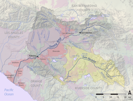
Santa Ana River map
Santa Ana River map

Temescal Creek (shown on federal maps as Temescal Wash) is an approximately 29-mile-long (47 km) watercourse in Riverside County, in the U.S. state of California. Flowing primarily in a northwestern direction, it connects Lake Elsinore with the Santa Ana River. It drains the eastern slopes of the Santa Ana Mountains on its left and on its right the western slopes of the Temescal Mountains along its length. With a drainage basin of about 1,000 square miles (2,600 km2), it is the largest tributary of the Santa Ana River, hydrologically connecting the 720-square-mile (1,900 km2) San Jacinto River and Lake Elsinore watersheds to the rest of the Santa Ana watershed. However, flowing through an arid rain shadow zone of the Santa Ana Mountains, and with diversion of ground water for human use, the creek today is ephemeral for most of its length, except for runoff from housing developments and agricultural return flows.

Excerpt from the Wikipedia article Temescal Creek (Riverside County) (License: CC BY-SA 3.0, Authors, Images).

Temescal Creek (Riverside County)

Geographical coordinates (GPS) Address Nearby Places
placeShow on map

Wikipedia: Temescal Creek (Riverside County)Continue reading on Wikipedia

Geographical coordinates (GPS)

Latitude Longitude
N 33.906111111111 ° E -117.61388888889 °
placeShow on map

Address

Riverside County


California, United States
mapOpen on Google Maps

Santa Ana River map
Santa Ana River map
Share experience

Nearby Places

Prado Reservoir
Prado Reservoir

Prado Reservoir is a reservoir in northwestern Riverside County and southwestern San Bernardino County, a couple of miles west of the city of Corona, in the U.S. state of California. The reservoir has a capacity of 362,000 acre-feet (447,000,000 m3) and is formed by Prado Dam on the Santa Ana River. The dam is composed of rock-fill and has a height of 106 feet (32 m) above the original streambed. It was built on the upper end of the Lower Santa Ana River Canyon, where there is a natural constriction in the river. It is below 2,255 square miles (5,840 km2) of the 2,450-square-mile (6,300 km2) Santa Ana River watershed. The dam was built by the United States Army Corps of Engineers and was completed in 1941. Prado Dam and Prado Reservoir provide flood control and water conservation. Their operation is coordinated with the facilities upstream. Prado Reservoir is not a storage reservoir, so water is released as quickly as possible while still allowing for groundwater recharge. When the water level reaches the top of the buffer pool, whose size changes depending on time of year, water is released at the maximum rate that the downstream channel will safely allow. As of 2006, the capacity of the channel is 5,000 cubic feet (140 m3) per second (140 m³/s), but channelization will eventually increase the capacity to 30,000 cubic feet (850 m3) per second (850 m³/s). During flood season, the buffer pool only has a capacity of 8,437 acre-feet (10,407,000 m3), while outside of flood season, the capacity increases to 25,760 acre-feet (31,770,000 m3). Since this is 2.3 and 7.1 percent of the reservoir's total capacity, respectively, the reservoir is usually fairly empty.