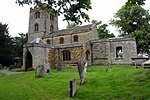
Hartwell, Northamptonshire
Northamptonshire geography stubsUse British English from March 2014Villages in NorthamptonshireWest Northamptonshire District

Hartwell is a village and civil parish in West Northamptonshire, England, bordering Buckinghamshire. The village is next to Salcey Forest and the M1 motorway. It is 7 miles (11 km) south of Northampton and 13 miles (21 km) north of Milton Keynes. The villages name means 'Hart spring/stream'.
Excerpt from the Wikipedia article Hartwell, Northamptonshire (License: CC BY-SA 3.0, Authors, Images).Hartwell, Northamptonshire
Forest Road,
Geographical coordinates (GPS) Address Nearby Places Show on map
Geographical coordinates (GPS)
| Latitude | Longitude |
|---|---|
| N 52.147 ° | E -0.854 ° |
Address
Forest Road
NN7 2HE , Hartwell
England, United Kingdom
Open on Google Maps


